Terrain
Road Map
Satellite
Hybrid
Terrain

 | Salicaceae 1. Salix hookeriana Barratt ex Hook.U.S.A., Alaska: [locality and coordinates withheld; status in Alaska: S2S3 (Imperiled to Vulnerable; ACCS)] Elev. 15 ft. Supra-tidal grass-forb meadow and willow shrublands. Mesic, sandy-silty soil. Assoc. spp.: Leymus mollis, Angelica lucida, Lupinus nootkatensis, Festuca rubra, Achillea millefolium, Salix barclayi, Salix alexensis, Salix hookeriana. Shrubs 2 m tall. Collected tissue for DNA analysis, 3 females, 3 males, V. Moisson/S. Karrrenberg- Uppsala University. UAAH: 17458 Matthew Carlson MLC2023-003Jun 14, 2023 |  |
 | Salicaceae 2. Salix hookeriana Barratt ex Hook.U.S.A., Alaska: [locality and coordinates withheld; status in Alaska: S2S3 (Imperiled to Vulnerable; ACCS)] Elev. 15 ft. Supra-tidal grass-forb meadow and willow shrublands. Mesic, sandy-silty soil. Assoc. spp.: Leymus mollis, Angelica lucida, Lupinus nootkatensis, Festuca rubra, Achillea millefolium, Salix barclayi, Salix alexensis, Salix hookeriana. Shrubs 2 m tall. Collected tissue for DNA analysis, 3 females, 3 males, V. Moisson/S. Karrrenberg- Uppsala University. UAAH: 17540 Matthew Carlson MLC2023-003Jun 14, 2023 |  |
 | Salicaceae 3. Salix hookeriana BarrattU.S.A., Washington, San Juan County: Orcas Island, North Beach. Elev. 10 ft. 48.711935°, -122.91944°. Datum: WGS 84. Coordinate uncertainty: 398 meters. Georeferenced by Regina Johnson. Coordinate Source: Digital Map. Lowland mixed coniferous forest. With Pseudotsuga menziesii, Arbutus menziesii, Pinus contorta, Picea sitchensis. Common. At base of bluff just above beach. In sandy loam soil. Reproductive state: Flowers. Origin: Native. Regina Johnson 2022-020May 16, 2022With Walter Fertig WTU: 432468; WTU-V-099369 |  WTU-V-099369.jpg |
 | Salicaceae 4. Salix hookeriana Barratt ex Hook.United States, Washington, San Juan: Orcas Island, North Beach. Elev. 10 ft 48.711935°, -122.91944°. Lowland mixed coniferous forest. Pseudotsuga menziesii, Arbutus menziesii, Pinus contorta, Picea sitchensis Common. At base of bluff just above beach. In sandy loam soil. https://intermountainbiota.org WS: 402111; WS014630 Regina Johnson 2022-020May 16, 2022With Walter Fertig |  WS014630.JPG |
 | Salicaceae 5. Salix hookeriana Barratt ex Hook.United States, Oregon, Benton: Mary\'s River Natural Area; Brushy area between trail and creek. Elev. 216 feet 44.5413°, -123.2828°. Brushy area between trail and creek. Several vertical, little-branched stems about 7 feet tall, apparently coming from one base. https://oregonflora.org OSC-V-269925 Barbara L. Wilson 20992May 2, 2022 |  OSC-V-269925.jpg |
 | Salicaceae 6. Salix hookeriana Barratt ex Hook.U.S.A., Alaska, Kenai Peninsula County: [locality and coordinates withheld; status in Alaska: S2S3 (Imperiled to Vulnerable; ACCS)] Elev. 0 m. Stand of many shrub willow species shrub, ca 2m, molecular data shows relationship to barclayi-commutata-pseudomyrsinites clade UAAH: 20186 N. Wagner NW22.048Jun 15, 2022With M. Wagner |
 | Salicaceae 7. Salix hookeriana BarrattU.S.A., Washington, King County: A beaver-influenced, peatland, shrub wetland between Kimball Creek and Gardiners Creek. 47.500552° N, 121.808868° W Saturated to inundated seasonallys, part sun, seasonally inundated shrub-marsh peatland wetland. Common, shrub, erect. Reproductive state: Vegetative. Origin: Native. Patricia Johnson NWC21-WA-10038-U27Jul 27, 2021WTU: 459676; WTU-V-113525 |  WTU-V-113525.jpg |
 | Salicaceae 8. Salix hookeriana Barratt ex Hook.U.S.A., Oregon, Benton County: Irish Bend County Park on the Willamette River, ca. 5.5 air miles NE of Monroe, at the end of Irish Bend Road. Elev. 78 m. 44.360803° N, 123.2201° W River bank, sand and gravel with Symphoricarpos, Physocarpus, Salix, Cornus, Rubus, Populus. Tree 8 meters tall; no stipules present; flowers pistillate. SRP: 76328 Richard R. Halse 10659Apr 28, 2021 |  SRP076328.jpg |
 | Salicaceae 9. Salix hookeriana Barratt ex Hook.U.S.A., Oregon, Coos County: Remote. Sandy Creek covered bridge wayside (mouth of Sandy Creek at the Middle Fork of the Coquille River). Elev. 240 ft. 43.00626° N, 123.89104° W Baccharis pilularis ssp. consanguinea Reproductive state: Vegetative. Origin: Native. COCC: 6553 Cindy Roché 2021-46Oct 9, 2021 |  COCC6553.jpg |
 | Salicaceae 10. Salix hookeriana Barratt ex Hook.U.S.A., Oregon, Coos County: Remote; Sandy Creek covered bridge wayside at mouth of Sandy Creek on the Middle Fork of the Coquille River. Elev. 240 ft. 43.00626° N, 123.89104° W Reproductive state: Vegetative. Origin: Native. COCC: 6554 Cindy Roché 2021-46Oct 9, 2021 |  COCC6554.jpg |
 | Salicaceae 11. Salix hookeriana Barratt ex Hook.United States, Oregon, Benton: Irish Bend County Park, on the Willamette River, ca 5.5 air miles NE of Monroe, at the end of Irish Bend Road. Elev. 78 44.360803°, -123.2201°. Georeferenced by collector. River bank; sand and gravel. HerbariumSpecimenDuplicate: Salix hookeriana Tree, 8 meters tall, no stipules present; flowers pistillate. https://intermountainbiota.org WS: 400054; WS008324 Richard R. Halse 10659Apr 28, 2021 |  WS008324_1708641208_lg.jpg |
 | Salicaceae 12. Salix hookeriana Barratt ex Hook.United States, Oregon, Benton: Irish Bend County Park, on the Willamette River, ca. 5.5 air miles NE of Monroe, at the end of Irish Bend Road. Elev. 78 m 44.360803°, -123.2201°. River bank, sand and gravel. Symphoricarpos, Physocarpus, Salix, Cornus, Rubus, Populus Tree 8 meters tall; no stipules present; flowers pistillate. https://oregonflora.org OSC-V-268861 Richard R. Halse 10659Apr 28, 2021 | 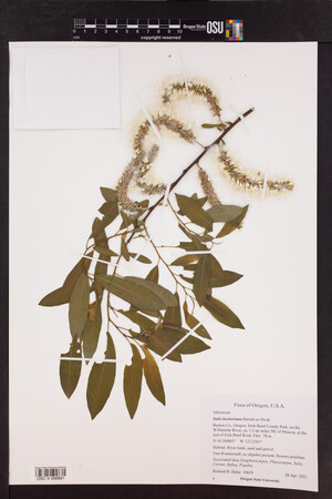 OSC-V-268861.jpg |
 | Salicaceae 13. Salix hookeriana Barratt ex Hook.United States, Oregon, Benton: Irish Bend County Park, on the Willamette River, ca. 5.5 air miles NE of Monroe, at the end of Irish Bend Road. Elev. 78 m 44.360803°, -123.2201°. River bank, sand and gravel. Symphoricarpos, Rubus, Populus, Salix lasiandra, Salix lasiolepis, Salix sitchensis Shrub 4 meters tall; flowers pistillate. https://oregonflora.org OSC-V-268915 Richard R. Halse 10637Apr 16, 2021 | 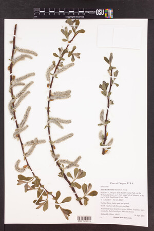 OSC-V-268915.jpg |
 | Salicaceae 14. Salix hookeriana Barratt ex Hook.U.S.A., Oregon, Clackamas County: Peach Cove Fen, 3 mi NNE of Canby. Elev. 135 ft. 45.300518° N, 122.674652° W; T03S, R01E, N 1/2 Sec. 22. Datum: WGS 84. Coordinate uncertainty: 106 meters. Coordinate Source: Digital Map. On floating fen mat. With Spiraea douglasii, Sphagnum squarrosum, Menyanthes trifoliata. HPSU: 22180 Patrick Hendrix s.n.Jun 25, 2020With John Christy |  HPSU_022180.jpg |
 | Salicaceae 15. Salix hookeriana Barratt ex Hook.U.S.A., Oregon, Clackamas County: Seasonal island immediately east of Rock Island in the Willamette River. Adjacent to Highway 99 east and railroad tracks. Elev. 70 ft. 45.321129°, -122.66097°. Datum: WGS 84. Georeferenced by Dominic Maze. Coordinate Source: Digital Map. Lower elevation, downstream side of island with deep, sandy soils and mature canopy of Quercus garryana, Acer macrophyllum, and Arbutus. Abundant. With Commandra, Collinsia parviflora, Koeleria, and Quercus garryana. Reproductive state: Flowers. Origin: Native. HPSU: 22694 Dominic Maze 1658Apr 16, 2020With Monte Mattsson |
 | Salicaceae 16. Salix hookeriana Barratt ex Hook.United States, Washington, Grays Harbor: Pacific Coast Range: Preacher Slough Trail (old railroad bed) along south boundary of Chehalis River Surge Plain Natural Area Preserve, 3 air miles SW of Montesano. T17N R8W S22 SE4 NE4 SE4. Elev. 20 ft 46.941461°, -123.65727°. Datum: WGS84. River edge in Phalaris arundinacea marsh with scattered Salix hookeriana, Salix sitchensis, Physocarpus capitatus, and Rosa nutkana var. nutkana. HerbariumSpecimenDuplicate: Salix hookeriana Pistillate shrub 12 ft tall. With sessile, elongate, thick catkins. Uncommon. https://intermountainbiota.org WS: 400643; WS008900 Walter Fertig 34453May 10, 2020 |  WS008900_1689289781_lg.jpg |
 | Salicaceae 17. Salix hookeriana Barratt ex Hook.United States, Oregon, Linn: Where American Drive crosses Spoon Creek, west of Halsey. Elev. 288 ft. 44.38893°, -123.04789°. Line of willows at edge of wet road ditch with snipe and a wet field. This was the only willow I saw in full flower in an afternoon of driving around this part of the Willamette Valley. iNaturalist observation #38453089; line of willows. https://oregonflora.org OSC-V-267377 Barbara L. Wilson 19845Feb 8, 2020 | 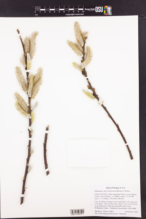 OSC-V-267377_lg.jpg |
 | Salicaceae 18. Salix hookeriana Barratt ex Hook.United States, Oregon, Benton: E. E. Wilson Wildlife Area, along the westernmost paved road, north of Camp Adair Road. Elev. 225 ft 44.707647°, -123.21771°. Road ditch. INaturalist observation #41184551; Shrub maybe 15 feet tall. Branches brittle at base. https://oregonflora.org OSC-V-270028 Barbara L. Wilson 19883Mar 31, 2020 |  OSC-V-270028.jpg |
 | Salicaceae 19. Salix hookeriana BarrattU.S.A., Washington, Jefferson County: Olympic National Forest. Quinault River. North bank from entrance to Olympic National Park west for approximately 2 kms. Elev. 130 m. 47.5307° N, 123.6981° W Datum: WGS 84. Coordinate uncertainty: 1000 meters. Coordinate Source: Digital map. River floodplain with cobbly areas, slightly elevated areas with Alnus rubra and Salix sitchensis dominant, sand embankments, and a beaver pond. Common and abundant throughout area in dry to wet soils. Reproductive state: Vegetative. Origin: Native. David Giblin 7188Aug 28, 2019WTU: 426758; WTU-V-073174 |  WTU-V-073174.jpg |
 | Salicaceae 20. Salix hookeriana BarrattU.S.A., Washington, Clallam County: Olympic National Forest. Beaver Lake, main parking area with asphalt and gravel parking area. Elev. 170 m. 48.11308° N, 124.24767° W Datum: WGS 84. Coordinate uncertainty: 30 meters. Coordinate Source: Specimen Label. Edge of pond dominated by Iris pseudacorus, Spiraea douglasii, and Salix sp. Carex obnupta and Nuphar polysepala emergent and dominant. Common on edge of lake; shrubs to 5 meters tall. Reproductive state: Vegetative. Origin: Native. David Giblin 6296Aug 28, 2018WTU: 419874; WTU-V-042905 |  WTU-V-042905.jpg |
 | Salicaceae 21. Salix hookeriana BarrattU.S.A., Washington, Grays Harbor County: Common shrub along edge of water; to 1.5 meters tall. Elev. 320 m. 47.40419° N, 123.60456° W Datum: WGS 84. Coordinate uncertainty: 100 meters. Coordinate Source: Digital map. Seasonal pond surrounded by Spiraea douglasii with adjacent cobbly upland. Common shrub along edge of water; to 1.5 meters tall. Reproductive state: Fruits. Origin: Native. David Giblin 6082May 22, 2018WTU: 419667; WTU-V-043000 |  WTU-V-043000.jpg |
 | Salicaceae 22. Salix hookeriana Barratt ex Hook.U.S.A., Washington, Grays Harbor County: none given Elev. 320 m. 47.40419° N, 123.60456° W Datum: WGS 84. Coordinate uncertainty: 100 meters. Coordinate Source: Specimen Label. Seasonal pond surrounded by Spiraea douglasii with adjacent cobbly upland. Common shrub along edge of water; to 1.5 m tall. SRP: 68943 David Giblin 6082May 22, 2018 |  SRP068943.jpg |
 | Salicaceae 23. Salix hookeriana Barratt ex Hook.U.S.A., Oregon, Multnomah County: Portland. Columbia Slough. Near NE 13th Ave. and Gertz Rd. 45.589079° N, 122.649847° W Coordinate Source: Specimen Label. Wet field. Common. Male flowers. Reproductive state: Flowers. HPSU: 20758 Dominic Maze 768Mar 19, 2018 |  HPSU_020758.jpg |
 | Salicaceae 24. Salix hookeriana Barratt ex Hook.Canada, British Columbia: Metro Vancouver, Surrey, Colebrook Road, north side, 1.4 km west of King George Boulevard. Elev. 1 m 49.096917°, -122.83797°. Border of thick grassy neglected agricultural land, by slough ditch, among Phalaris arundinacea. Common along Colebrook Road; young plants with stems mostly 2-3 m tall, female catkins on this plant mostly 10-11 cm, longest measured 13 cm, glabrous proximally, but with white tangled hairs distally, styles about 1 mm. UBC: V253234 Frank Lomer 11036Apr 18, 2018 |
 | Salicaceae 25. Salix hookeriana Barratt ex Hook.United States, Oregon, Multnomah: West of Multnomah Channel. 45.6797°, -122.8722°. Floodplain backwater swamp. https://oregonflora.org OSC-V-263832 George Kral 759Mar 29, 2018 | 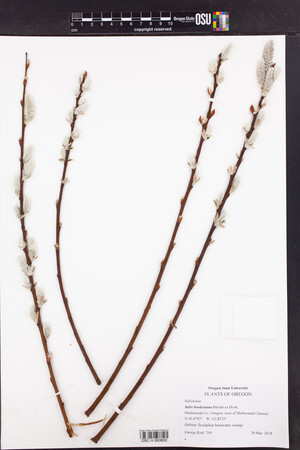 OSC-V-263832_lg.jpg |
 | Salicaceae 26. Salix hookeriana Barratt ex Hook.United States, Washington, Grays Harbor: Pacific Coast, Griffiths-Priday State Park west of WA Hwy 109 and west of Copalis Beach. T19N R12W S28 SE4 NW4 NE4. Elev. 10 ft 47.111806°, -124.17968°. Beach shrub community of Morella californica, Salix hookeriana, Vaccinium ovatum, Pinus contorta var. contorta, and Picea sitchensis on sandy soil. HerbariumSpecimenDuplicate: Salix hookeriana Shrub 5 ft tall, leaves white-hairy beneath. Locally common. https://intermountainbiota.org WS: 412858; WS038063 Walter Fertig 33138Jul 20, 2018With Laura Fertig |  WS038063.JPG |
 | Salicaceae 27. Salix hookeriana Barratt ex Hook.U.S.A., Oregon, Washington County: Butler Wetland. Elev. 130 ft. 45.414° N, 122.902° W Datum: WGS 84. Georeferenced by Katya Davidson. Coordinate Source: Digital Map. Edge of marsh. HPSU: 21518 George Kral 649May 30, 2017 |  HPSU_021518.jpg |
 | Salicaceae 28. Salix hookeriana Barratt ex Hook.U.S.A., Oregon, Washington County: Golf Course Road bridge over Tualatin River. Elev. 150 ft. 45.502° N, 123.057° W Wet soils under bridge. HPSU: 25148 George Kral 636May 8, 2017 |  HPSU_025148.jpg |
 | Salicaceae 29. Salix hookeriana Barratt ex Hook.U.S.A., Oregon, Benton County: E. E. Wilson Wildlife Area north of Adair Village. Elev. 220 ft. 44.7023° N, 123.199° W Edge of sunny openign by small pond. Shrub about 10 feet tall. SRP: 82449 Barbara L. Wilson 18980Apr 10, 2017 |  SRP082449.jpg + 1 more image |
 | Salicaceae 30. Salix hookeriana Barratt ex Hook.United States, Oregon, Benton: At the northern edge of a landslide intersecting Forest Road 830, McDonald Forest. Elev. 166 44.637474°, -123.31955°. Georeferenced by [automated process-OregonFlora/OSU Herb]. Coordinate Source: OrlookId: 125002, StateProvince: Oregon, County: Benton, LocName: Lat 44 Deg 38 Min 14.907 Sec; Lon -123 Deg 18.44 Min 44 Sec. OregonFlora 1994-2020 methodology. Wet grassy slope. Acer macrophyllum, Pseudotsuga menziesii var. menziesii, Hypericum perforatum, Corylus cornuta var. californica https://oregonflora.org OSC-V-255893 Alexander Abair 183Apr 15, 2017 | 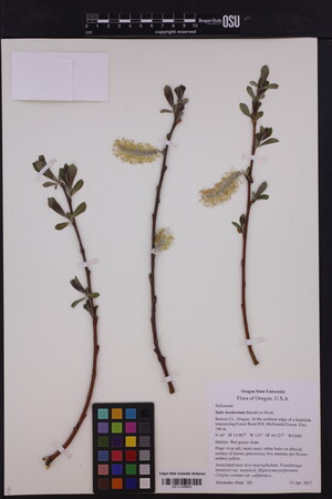 OSC-V-255893_lg.jpg |
 | Salicaceae 31. Salix hookeriana Barratt ex Hook.United States, Oregon, Washington: Butler Wetland. Elev. 130 ft. 45.412°, -122.903°. Georeferenced by [automated process-OregonFlora/OSU Herb]. Coordinate Source: OrlookId: 125496, StateProvince: Oregon, County: Washington, LocName: Lat 45.412 Deg; Lon -122.903 Deg. OregonFlora 1994-2020 methodology. Edge of marsh. https://oregonflora.org OSC-V-257388 George Kral 649May 30, 2017 | 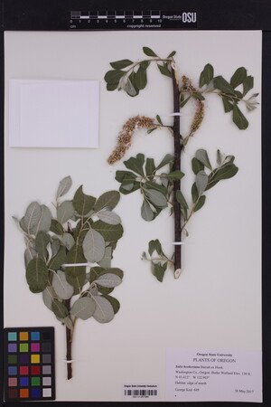 OSC-V-257388_lg.jpg |
 | Salicaceae 32. Salix hookeriana Barratt ex Hook.United States, Oregon, Washington: Golf Course Road bridge over Tualatin River. Elev. 150 ft. 45.502°, -123.057°. Georeferenced by [automated process-OregonFlora/OSU Herb]. Coordinate Source: OrlookId: 125493, StateProvince: Oregon, County: Washington, LocName: Lat 45.502 Deg; Lon -123.057 Deg. OregonFlora 1994-2020 methodology. Wet soils under bridge. https://oregonflora.org OSC-V-257376 George Kral 636May 8, 2017 |
 | Salicaceae 33. Salix hookeriana BarrattU.S.A., Washington, Pierce County: JBLM, TA-5, roadside wetland. Elev. 105 m. 47.05059° N, 122.57736° W Datum: WGS 84. Coordinate Source: GPS. Occasional shrubs to 2 m tall. Origin: Native. Peter Dunwiddie PWD-16-279Jun 24, 2016With Rod Gilbert, Sarah Krock, Peter Zika WTU: 445809; WTU-V-104370 |  WTU-V-104370.jpg |
 | Salicaceae 34. Salix hookeriana Barratt ex Hook.Canada, British Columbia: Metro Vancouver, Surrey, South Fraser Perimeter Road (Highway 17), north side, ca. 200 m south of Tannery Road overpass. Elev. 4 m 49.194722°, -122.89541°. Shrubby highway ditchbank. Stout shrub 3 m tall; full of male catkins just starting to flower. UBC: V246501 Frank Lomer 9162Apr 29, 2015 |
 | Salicaceae 35. Salix hookeriana Barratt ex Hook.U.S.A., Alaska: [locality and coordinates withheld; status in Alaska: S2S3 (Imperiled to Vulnerable; ACCS)] UAAH: 7612 Matthew Carlson MLC 2014-091Jul 2014 |
 | Salicaceae 36. Salix hookeriana Barratt ex Hook.Canada, British Columbia: Vancouver, Iona Island. Elev. 1 m 49.21°, -123.2°. Several large shrubs in understory of open Populus trichocarpa woodland. UBC: V247914 Jamie D. Fenneman 2013-102Aug 23, 2013 |
 | Salicaceae 37. Salix hookeriana BarrattU.S.A., Washington, King County: Carkeek Park, Ballard, Seattle. Elev. 200 ft. 47.710528°, -122.36974°. Datum: WGS 84. Coordinate uncertainty: 1000 meters. Georeferenced by Ibro Polovina. Coordinate Source: Digital Map. On hill near creek bed. Tree with leaves having entire margins; yellow catkins. Collected for Biology 317 (Plant Identification and Classification). Reproductive state: Flowers. Origin: Native. WTU: 390038 June Landenburger 1207Apr 22, 2012 |
 | Salicaceae 38. Salix hookeriana BarrattU.S.A., Oregon, Clatsop County: Coastal Strand, south of Arch Cape, 5 highway miles south of Cannon Beach. Elev. 25 ft. UTM Zone 10, 425286E, 5075230N 45.826585°, -123.96189°. Datum: WGS 84. Georeferenced by Dan Post. Coordinate Source: Calc. from UTM. Inland edge of cobbly beach. With Angelica, Lathyrus littoralis. Shrub 3 meters tall. Reproductive state: Fruits. Origin: Native. WTU: 396722 Nick Otting 3365Apr 28, 2012 |
 | Salicaceae 39. Salix hookeriana BarrattCanada, British Columbia: Fraser Valley, fen between Agassiz Mountain and Bear Mountain, 1.88 kilometers east of Highway 9; 3 kilometers due southeast of Harrison Hotsprings. 200 meters north of wood powerline. Elev. 20 m. 49° 16\' 56.7" N, 121° 45\' 22.2" W Wet swampy ground; with Thuja plicata, Viburnum opulus, Cornus stolonifera, Frangula purshiana, Lysichiton americanus. Shrubs to 3 meters tall; leaves glaucous beneath, appearing smooth, but actually very sparsely short hairy on both sides, newer leaves with longer white hairs; catkins hairy, mostly fallen off. Reproductive state: Fruits. Origin: Native. WTU: 396565 Frank Lomer 7614Jun 7, 2011 |
 | Salicaceae 40. Salix hookeriana Barratt ex Hook.Canada, British Columbia: Fraser Valley, fen between Agassiz Mountain and Bear Mountain, 1.88 km east of Highway 9; 3 km due southeast of Harrison Hotsprings. Elev. 20 m 49.282417°, -121.75616°. Wet swampy ground 200 meters north of wood powerline; with Thuja plicata, Viburnum opulus, Cornus stolonifera, Frangula purshiana, Lysichiton americanus. Shrubs to 3 m tall; leaves glaucous beneath, appearing smooth, but actually very sparsely short hairy on both sides, newer leaves with longer white hairs; catkins hairy,mostly fallen off; plants unlike typical Salix hookeriana plants I know. UBC: V236377 Frank Lomer 7614Jun 7, 2011 |
 | Salicaceae 41. Salix hookeriana Barratt ex Hook.Canada, British Columbia: Fraser Valley, fen between Agassiz Mountain and Bear Mountain, 2 km east of Highway 9; 3 km due southeast of Harrison Hotsprings. Elev. 20 m 49.280278°, -121.75555°. Shrubby part of fen, south of wood powerline. Style 1 mm long; plants intermediate in hairiness between Lomer 7614 and 7615. UBC: V236379 Frank Lomer 7616Jun 7, 2011 |
 | Salicaceae 42. Salix hookeriana Barratt ex Hook.United States, Oregon, Lane: Baker Beach, Siuslaw National Forest; at the end of Baker Beach Road, ca. 7 miles north of Florence off of U.S. Hwy. 101. Elev. 8 44.087689°, -124.11820°. Georeferenced by [automated process-OregonFlora/OSU Herb]. Coordinate Source: OrlookId: 58083, StateProvince: Oregon, County: Lane, LocName: Lat 44 Deg 5 Min 15.68 Sec; Lon -124 Deg 7 Min 5.53 Sec. OregonFlora 1994-2020 methodology. Carex, Juncus, Myrica, Ledum, Gaultheria, Ulex, Salix sitchensis. https://oregonflora.org Richard R. Halse 7867Apr 29, 2010OSC: Accession Number: OSC225009 |
 | Salicaceae 43. Salix hookeriana Barratt ex Hook.U.S.A., Oregon, Lincoln County: Newport. Lighthouse park, several yards north of north Jetty. Elev. 0 ft. 44.62346° N, 124.06411° W on ocean beach at base of cliff. COCC: 6591 Barbara L. Wilson 15892Sep 6, 2009 |  COCC6591.jpg |
 | Salicaceae 44. Salix hookeriana Barratt ex Hook.Canada, British Columbia: Spanish Banks, Point Grey, Vancouver. Elev. 5 m 49.27859°, -123.22755°. Sea inlet rocky shore line. Tree/tall shrub to 4 m. UBC: V248762 Diana M. Percy DPsitchSBMay 8, 2008 |
 | Salicaceae 45. Salix hookeriana Barratt ex Hook.Canada, British Columbia: Haida Gwaii (Queen Charlotte Islands), Moresby Island, 11.2 km south of Sandspit, adjacent to Copper Bay. Elev. 4 m 53.16883°, -131.79469°. Open, shaded woods with Poa, Salix scouleriana, Poa, Myosotis, Galium boreale, Salix hookeriana, Pseudotsuga, Phalaris arundinacea, Alnus. Tree to 7 m. UBC: V244774 Diana M. Percy | Jeffery M. Saarela Saarela 1297Jul 25, 2007 |
 | Salicaceae 46. Salix hookeriana Barratt ex Hook.Canada, British Columbia: Vancouver Island, along Highway 14 (Sooke Highway) Elev. 74 m 48.42439°, -123.55156°. Roadside ditch with Dactylis glomerata, Holcus, Bromus sterilis, Bromus hordeaceus, scotch broom, Anthoxanthum odoratum, Poa, Phalaris arundinacea, Salix spp., Lotus corniculatus. UBC: V244819 Diana M. Percy | Jeffery M. Saarela | Ying Chang Saarela 865Jun 4, 2007 |
 | Salicaceae 47. Salix hookeriana Barratt ex Hook.Canada, British Columbia: Vancouver Island, approx. 2 km north of Port Renfrew, along Deering Road. Elev. 15 m 48.58372°, -124.38211°. Roadside ditch with Anthoxanthum odoratum, Thuja plicata, Cytisus scoparius, Aruncus dioicus, Polystichum munitum. UBC: V244824 Diana M. Percy | Jeffery M. Saarela | Ying Chang Saarela 885Jun 5, 2007 |
 | Salicaceae 48. Salix hookeriana Barratt ex Hook.Canada, British Columbia: Vancouver Island, along Highway 18, east of town of Lake Cowichan, just east of Cowichan River Provincial Park. Elev. 343 m 48.80694°, -123.95692°. Roadside with Dactylis glomerata, Anthoxanthum odoratum, Poa, Festuca, Acer macrophyllum, Populus, Alnus rubra. UBC: V244831 Diana M. Percy | Jeffery M. Saarela | Ying Chang Saarela 900Jun 6, 2007 |
 | Salicaceae 49. Salix hookeriana Barratt ex Hook.Canada, British Columbia: Vancouver Island, just off Highway 19, along road to Courtenay, before turnoff to Forbidden Plateau Road. Elev. 96 m 49.69706°, -125.07661°. With Populus, Salix sitchensis, scotch broom, Festuca rubra, Alnus, Pseudotsuga. Shrub 2-3 m. UBC: V244843 Diana M. Percy | Jeffery M. Saarela | Ying Chang Saarela 942Jun 7, 2007 |
 | Salicaceae 50. Salix hookeriana Barratt ex Hook.Canada, British Columbia: Vancouver Island, west of Courtenay, 6.1 km down from Mount Washington alpine resort/ski area. Elev. 849 m 49.74439°, -125.2445°. Gravel roadside with Alnus viridis. Shrub 1-2 m. UBC: V244850 Diana M. Percy | Jeffery M. Saarela | Ying Chang Saarela 956Jun 7, 2007 |


