Terrain
Road Map
Satellite
Hybrid
Terrain

 | Apiaceae 1. Heracleum mantegazzianum Sommier & LevierU.S.A., Oregon, Multnomah County: Northeast Portland. Columbia River Slough. Private property 100 meters south of Northeast South Shore Road and 200 meters west of Northeast 14th Avenue. Elev. 10 ft. 45.596004°, -122.65529°. Datum: WGS 84. Georeferenced by Dominic Maze. Coordinate Source: Digital Map. Swale with Fraxinus latifolia, Salix jucida, S. scouleri, S. sitchensis. Adventive. ~100 individuals. To 3-4 meters tall, hairy, blotched stems. Just beginning to flower. Will undergo eradication efforts. 1 of 2 Reproductive state: Flowers. Origin: Introduced. HPSU: 22295 Dominic Maze 1499Jun 1, 2018 |  HPSU_022295.jpg |
 | Apiaceae 2. Heracleum mantegazzianum Sommier & LevierU.S.A., Oregon, Multnomah County: Northeast Portland. Columbia River Slough. Private property 100 meters south of Northeast South Shore Road and 200 meters west of Northeast 14th Avenue. Elev. 10 ft. 45.596004°, -122.65529°. Datum: WGS 84. Georeferenced by Dominic Maze. Coordinate Source: Digital Map. Swale with Fraxinus latifolia, Salix jucida, S. scouleri, S. sitchensis. Adventive. ~100 individuals. To 3-4 meters tall, hairy, blotched stems. Just beginning to flower. Will undergo eradication efforts. 2 of 2 Reproductive state: Flowers. Origin: Introduced. HPSU: 22296 Dominic Maze 1500Jun 1, 2018 |  HPSU_022296.jpg |
 | Apiaceae 3. Heracleum mantegazzianum Sommier & LevierFrance, Provence-Alpes-Côte d\'Azur, Hautes-Alpes: Villar-d\'Arêne: Col du Lautaret: Jardin Botanique Alpin du Lautaret: Invaded plot. Elev. 2065 m. 45° 2\' 7.75" N, 6° 23\' 57.5" E Datum: WGS 84. Georeferenced by Hannah Marx. Coordinate Source: Specimen Label. South-facing invaded streamside plot. Leaf tissue in silica gel at ID. Reproductive state: Vegetative. Origin: Introduced. ID: 190894; ID196450 Hannah Marx 2014-016Jul 3, 2014With Sébastien Lavergne |  ID196450.jpg |
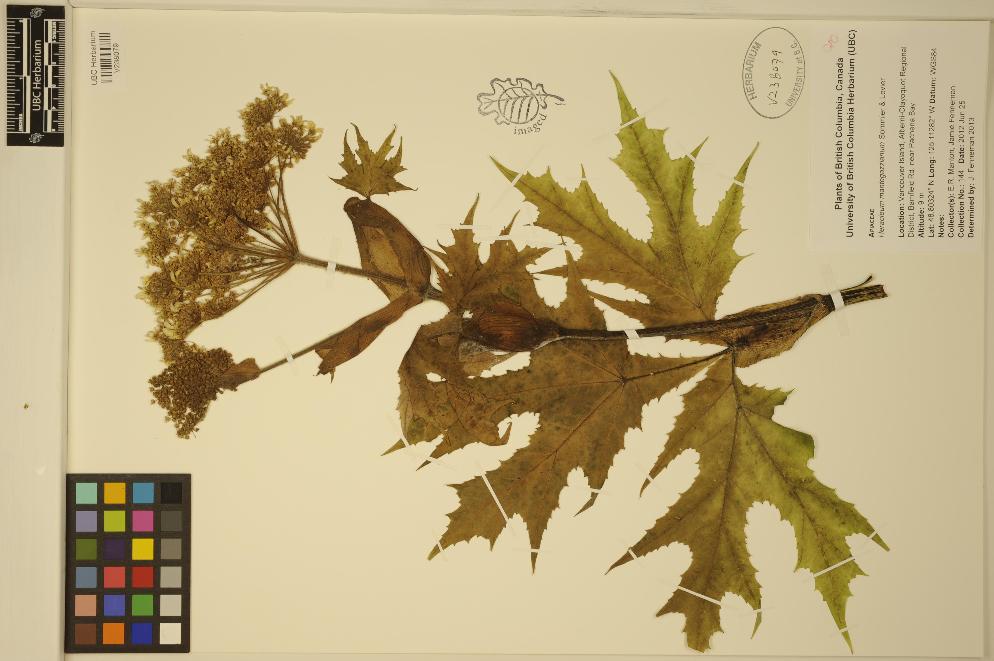
 | Apiaceae 4. Heracleum mantegazzianum Sommier & LevierCanada, British Columbia: Vancouver Island, Alberni-Clayoquot Regional District, Bamfield Rd. near Pachena Bay. Elev. 9 m 48.80324°, -125.11282°. UBC: V238079 Erin R. Manton | Jamie D. Fenneman 144Jun 25, 2012 |  V238079.jpg |
 | Apiaceae 5. Heracleum mantegazzianum Sommier & LevierU.S.A., Washington, Mason County: Route 106 about 3 miles east of Union, south shore of Hood Canal. Elev. 9 ft. 47° 21\' N, 123° 2.3\' W Wet ditch, with Equisetum telmateia, Oenanthe, Rubus parviflorus, Acer macrophyllum. One large 2 meter tall plant, white flowers, leaves 1 meter long. SHEET 2 OF 2. Reproductive state: Flowers. Origin: Introduced. WTU: 382452 Peter F. Zika 25105Jul 4, 2010 |
 | Apiaceae 6. Heracleum mantegazzianum Sommier & LevierU.S.A., Washington, Mason County: Route 106 about 3 miles east of Union, south shore of Hood Canal. Elev. 9 ft. 47° 21\' N, 123° 2.3\' W Wet ditch, with Equisetum telmateia, Oenanthe, Rubus parviflorus, Acer macrophyllum. One large 2 meter tall plant, white flowers, leaves 1 meter long. SHEET 1 OF 2. Reproductive state: Flowers. Origin: Introduced. WTU: 382451 Peter F. Zika 25105Jul 4, 2010 |
 | Apiaceae 7. Heracleum mantegazzianum Sommier & LevierU.S.A., Washington, King County: West Seattle. 4027 49th Avenue SW. Elev. 328 ft. 47.567674° N, 122.395211° W Disturbed area in back corner of residential lot. Several stems to 10 cm. in diameter; plants to 2.5 meters tall; flowers white. Reproductive state: Flowers & Fruits. Origin: Introduced. WTU: 376158 David Giblin 2990Jun 26, 2009 |
 | Apiaceae 8. Heracleum mantegazzianum Sommier & LevierU.S.A., Washington, King County: Seattle. Backyard of residence at 3314 Wallingford Avenue North. About 0.5 km north of Gas Works Park. 47.64933° N, 122.34306° W Datum: WGS 84. Coordinate uncertainty: 5 meters. Coordinate Source: Digital map. Highly disturbed, shaded soil. Plants from rhizomes; to 3 meters tall; flowers white; plants eradicated. SHEET 1 of 2. Specimen used for illustration in Revision of Flora of the Pacific Northwest WTU Herbarium, 2015. Reproductive state: Flowers & Fruits. Origin: Introduced. David Giblin 3041Jul 17, 2009With Karen Peterson WTU: 376155; WTU-V-052950 |  WTU-V-052950.jpg |
 | Apiaceae 9. Heracleum mantegazzianum Sommier & LevierU.S.A., Washington, King County: Seattle. Backyard of residence at 3314 Wallingford Avenue North. About 0.5 km north of Gas Works Park. 47.64933° N, 122.34306° W Datum: WGS 84. Coordinate uncertainty: 5 meters. Coordinate Source: Digital map. Highly disturbed, shaded soil. Plants from rhizomes; to 3 meters tall; flowers white; plants eradicated. SHEET 2 of 2. Reproductive state: Flowers & Fruits. Origin: Introduced. David Giblin 3041Jul 17, 2009With Karen Peterson WTU: 376159; WTU-V-052945 |  WTU-V-052945.jpg |
 | Apiaceae 10. Heracleum mantegazzianum Sommier & LevierUnited States, Washington, King: West Seattle; 4027 49th Avenue SW. Elev. 328 ft. 47.567674°, -122.39521°. Georeferenced by [automated process-OregonFlora/OSU Herb]. Coordinate Source: OrlookId: 117472, StateProvince: Washington, County: King, LocName: Lat 47.567674 Deg; Lon -122.395211 Deg. OregonFlora 1994-2020 methodology. Disturbed area in back corner of residential lot. HerbariumSpecimenDuplicate: Heracleum mantegazzianum https://oregonflora.org David Giblin 2990Jun 26, 2009OSC: Accession Number: OSC231109 |
 | Apiaceae 11. Heracleum mantegazzianum Sommier & LevierU.S.A., Washington, Mason County: On both sides of Route 101, near shore of Annas Bay, The Great Bend, Hood Canal. Elev. 131 ft. 47° 21.1\' N, 123° 9.6\' W Perhaps 50 plants naturalized. SHEET 2 OF 2. Reproductive state: Flowers. Origin: Introduced. WTU: 365228 Peter F. Zika 22833Jul 3, 2006 |
 | Apiaceae 12. Heracleum mantegazzianum Sommier & LevierU.S.A., Washington, Mason County: On both sides of Route 101, near shore of Annas Bay, The Great Bend, Hood Canal. Elev. 131 ft. 47° 21.1\' N, 123° 9.6\' W Perhaps 50 plants naturalized. SHEET 1 OF 2. Reproductive state: Flowers. Origin: Introduced. WTU: 365227 Peter F. Zika 22833Jul 3, 2006 |
 | Apiaceae 13. Heracleum mantegazzianum Sommier & LevierU.S.A., Washington, King County: Route 520 right-of-way, Montlake, Seattle. Elev. 49 ft. 47° 38\' N, 122° 19\' W Shaded thickets. Rare. Reproductive state: Flowers & Fruits. Origin: Introduced. WTU: 366180 Peter F. Zika 22797Jun 18, 2006 |
 | Apiaceae 14. Heracleum mantegazzianum Sommier & Lev.Canada, British Columbia, Vancouver Island: (locality not given). Elev. 31 m 48.4675°, -123.42555°. Coordinate Source: Source. Several plants here and in yard across street. Conservation Status:CDC: Not Listed. V191524 Kendrick Marr KM5940Jun 20, 2004 |
 | Apiaceae 15. Heracleum mantegazzianum Sommier & LevierUnited States, Oregon, Lane: Eugene; West 8th Alley (east/west alley connecting Washington and Jefferson Sts., between 8th Avenue and Broadway (9th); private property of duplex 550 and 552 W. 8th avenue. 44.0522°, -123.0856°. Georeferenced by Katie E. Mitchell. Coordinate Source: OrlookId: 102427, StateProvince: Oregon, County: Lane, LocName: Eugene. OregonFlora 1994-2020 methodology. Backyard and in cultivated border surrounding private property of duplex, in residential neighborhood; spreading into unpaved alley and to adjoining properties. Himalayan blackberry, burdock, cultivated bamboo, Sisymbrium officinale https://oregonflora.org Rhoda M. Love 20016Jun 7, 2001With Rhoda Love OSC: Accession Number: OSC217255 |  OSC217255_1.jpg |
 | Apiaceae 16. Heracleum mantegazzianum Sommier & LevierUnited States, Oregon, Lane: Eugene; West 8th Alley (east/west alley connecting Washington and Jefferson Sts., between 8th Avenue and Broadway (9th) Sts.; private property of duplex, 550 and 552 W. 8th avenue in residential neighborhood. 44.0522°, -123.0856°. Georeferenced by Katie E. Mitchell. Coordinate Source: OrlookId: 102427, StateProvince: Oregon, County: Lane, LocName: Eugene. OregonFlora 1994-2020 methodology. Back yard and in cultivated border surrounding private property of duplex, in residential neighborhood; spreading into unpaved alley and to adjoining properties. HerbariumSpecimenDuplicate: Heracleum mantegazzianum https://oregonflora.org Rhoda M. Love 20012May 23, 2001With Rhoda Love OSC: Accession Number: OSC217256 |  OSC217256_2.jpg |
 | Apiaceae 17. Heracleum mantegazzianum Sommier & LevierUnited States, Oregon, Lane: Eugene; West 8th Alley (east/west alley connecting Washington and Jefferson Sts., between 8th Avenue and Broadway (9th) Sts.; private property of duplex, 550 and 552 W. 8th avenue in residential neighborhood. 44.0522°, -123.0856°. Georeferenced by Katie E. Mitchell. Coordinate Source: OrlookId: 102427, StateProvince: Oregon, County: Lane, LocName: Eugene. OregonFlora 1994-2020 methodology. Back yard and in cultivated border surrounding private property of duplex, in residential neighborhood; spreading into unpaved alley and to adjoining properties. HerbariumSpecimenDuplicate: Heracleum mantegazzianum https://oregonflora.org Rhoda M. Love 20012May 23, 2001With Rhoda Love OSC: Accession Number: OSC217257 |
 | Apiaceae 18. Heracleum mantegazzianum Sommier & LevierU.S.A., Washington, King County: University of Washington. 47.66667°, -122.30861°. Datum: WGS 84. Coordinate uncertainty: 10000 meters. Georeferenced by WTU Staff. Coordinate Source: GeoLocate. Reproductive state: Vegetative. Origin: Introduced. WTU: 343724 Jane Wentworth s.n.Jun 17, 1997 |
 | Apiaceae 19. Heracleum mantegazzianum Sommier & Lev.Canada, British Columbia, Gulf Islands: Denman Island: below East Road, 1.3 km S of intersection with Denman Road. 49.516667°, -124.73333°. Plant >7 ft (2m) tall, main stalk 7.5 cm diameter. Conservation Status:CDC: Not Listed. V172361A Judy Jamison 465Aug 5, 1996 |
 | Apiaceae 20. Heracleum mantegazzianum Sommier & Lev.Canada, British Columbia, Gulf Islands: Denman Island: below East Road, 1.3 km S of intersection with Denman Road. 49.516667°, -124.73333°. Plant >7 ft (2m) tall, main stalk 7.5 cm diameter. Conservation Status:CDC: Not Listed. V172361B Judy Jamison 465Aug 5, 1996 |
 | Apiaceae 21. Heracleum mantegazzianum Sommier & LevierU.S.A., Washington, Thurston County: [no locality given] IDE: 200; ID160933 Tapio s.n.May 11, 1992 |  ID160933.jpg |
 | Apiaceae 22. Heracleum mantegazzianum Sommier & LevierU.S.A., Washington, Thurston County: [no locality given] IDE: 201; ID160932 Tapio s.n.May 11, 1992 |  ID160932.jpg |
 | Apiaceae 23. Heracleum mantegazzianum Sommier & LevierU.S.A., Washington, Thurston County: [no locality given] IDE: 202; ID160931 Tapio s.n.May 11, 1992 |  ID160931.jpg |
 | Apiaceae 24. Heracleum mantegazzianum Sommier & LevierUnited States, Washington, King: Seattle, along right-of-way, Lake Washington Blvd. 47.60639°, -122.33083°. Coordinate Source: Estimated. HerbariumSpecimenDuplicate: Heracleum mantegazzianum | herbariumSpecimenDuplicate: Heracleum mantegazzianum | herbariumSpecimenDuplicate: Heracleum mantegazzianum | herbariumSpecimenDuplicate: Heracleum mantegazzianum. Sheet 5 of 5. https://intermountainbiota.org WS: 342335 Catherine Hovanic 1447Jun 21, 1989With Cindy Roche |
 | Apiaceae 25. Heracleum mantegazzianum Sommier & LevierUnited States, Washington, King: Seattle, along right-of-way, Lake Washington Blvd. 47.60639°, -122.33083°. Coordinate Source: Estimated. HerbariumSpecimenDuplicate: Heracleum mantegazzianum | herbariumSpecimenDuplicate: Heracleum mantegazzianum | herbariumSpecimenDuplicate: Heracleum mantegazzianum | herbariumSpecimenDuplicate: Heracleum mantegazzianum. Sheet 1 of 5. https://intermountainbiota.org WS: 348514 Catherine Hovanic 1447Jun 21, 1989With Cindy Roche |
 | Apiaceae 26. Heracleum mantegazzianum Sommier & LevierUnited States, Washington, King: Seattle, along right-of-way, Lake Washington Blvd. 47.60639°, -122.33083°. Coordinate Source: Estimated. HerbariumSpecimenDuplicate: Heracleum mantegazzianum | herbariumSpecimenDuplicate: Heracleum mantegazzianum | herbariumSpecimenDuplicate: Heracleum mantegazzianum | herbariumSpecimenDuplicate: Heracleum mantegazzianum. Sheet 4 of 5. https://intermountainbiota.org WS: 303746 Catherine Hovanic 1447Jun 21, 1989With Cindy Roche |
 | Apiaceae 27. Heracleum mantegazzianum Sommier & LevierUnited States, Washington, King: Seattle, along right of way, Lake Washington Blvd. 47.60639°, -122.33083°. Coordinate Source: Estimated. HerbariumSpecimenDuplicate: Heracleum mantegazzianum | herbariumSpecimenDuplicate: Heracleum mantegazzianum | herbariumSpecimenDuplicate: Heracleum mantegazzianum | herbariumSpecimenDuplicate: Heracleum mantegazzianum. Sheet 3 of 5. https://intermountainbiota.org WS: 277738 Catherine Hovanic 1447Jun 21, 1989With Cindy Roche |
 | Apiaceae 28. Heracleum mantegazzianum Sommier & LevierUnited States, Washington, King: Seattle, along right of way, Lake Washington Blvd. 47.60639°, -122.33083°. Coordinate Source: Estimated. HerbariumSpecimenDuplicate: Heracleum mantegazzianum | herbariumSpecimenDuplicate: Heracleum mantegazzianum | herbariumSpecimenDuplicate: Heracleum mantegazzianum | herbariumSpecimenDuplicate: Heracleum mantegazzianum. Sheet 2 of 5. https://intermountainbiota.org WS: 277737 Catherine Hovanic 1447Jun 21, 1989With Cindy Roche |
 | Apiaceae 29. Heracleum mantegazzianum Sommier & LevierCanada, British Columbia: Greater Vancouver Regional District, New Westminster, Brunette River. 49.216667°, -122.91666°. Moist ground near river in tall grass. UBC: V195467 Frank Lomer s.n.Aug 28, 1988 |
 | Apiaceae 30. Heracleum mantegazzianum Sommier & LevierCanada, British Columbia: Greater Vancouver Regional District, New Westminster, near Brunette River. Surrounding large pond and in seepage area at base of hillside. Abundant,forming mats. UBC: V195433 Frank Lomer s.n.Aug 29, 1988 |
 | Apiaceae 31. Heracleum mantegazzianum Sommier & LevierU.S.A., Washington, Mason County: Skokomish Indian Reservation; along US Hwy 101, 3.5 miles south of Potlatc. Elev. 39 ft. T21N R4W S10 or 11 47.3224°, -123.1724°. Datum: NAD 27. Coordinate uncertainty: 805 meters. Georeferenced by Ben Legler. Coordinate Source: TRS2LL. Assoc. genera: Alnus, Urtica, Salix, Typha, Equisetum, Rubus. Flowers white; plants to 1.8 meters tall. Reproductive state: Flowers & Fruits. Origin: Introduced. WTU: 305320 Richard R. Halse 2910Jul 22, 1984 |
 | Apiaceae 32. Heracleum mantegazzianum Sommier & LevierU.S.A., Washington, Mason County: Skokomish Indian Reservation; along US Hwy 101, 3.5 miles south of Potlatc. Elev. 39 ft. T21N R4W S10 or 11 47.3224°, -123.1724°. Datum: NAD 27. Coordinate uncertainty: 805 meters. Georeferenced by Ben Legler. Coordinate Source: TRS2LL. Associated genera: Alnus, Urtica, Salix, Typha, Equisetum, Rubus. Flowers white; plants to 1.8 meters tall. 2 of 2. Reproductive state: Vegetative. Origin: Introduced. WTU: 305321 Richard R. Halse 2910Jul 22, 1984 |
 | Apiaceae 33. Heracleum mantegazzianum Sommier & LevierU.S.A., Washington, Mason County: Skokomish Indian Reservation; along U.S. Hwy. 101; 3.5 miles South of Potlatch. Elev. 12 m. Associated genera: Alnus, Urtica, Salix, Typha, Equisetum, Rubus. This specimen is on two sheets: inflorescence and infructescence (NY 622070) and leaf (NY 622071). Origin: N. NY: 00622071 R. R. Halse Jul 22, 1984 |
 | Apiaceae 34. Heracleum mantegazzianum Sommier & LevierU.S.A., Washington, Mason County: Skokomish Indian Reservation; along U.S. Hwy. 101; 3.5 miles South of Potlatch. Elev. 12 m. Associated genera: Alnus, Urtica, Salix, Typha, Equisetum, Rubus. This specimen is on two sheets: inflorescence and infructescence (NY 622070) and leaf (NY 622071). Origin: N. NY: 00622070 R. R. Halse Jul 22, 1984 |
 | Apiaceae 35. Heracleum mantegazzianum Sommier & LevierUnited States, Washington: Skokomish Indian Reservation, along US Highway 101, 3.5 miles south of potlatch, t21n, r4w, sec. 10, mason County. Elev. 12 m Flowers white;plants to 1.8 m.tall;associated genera of alnus, urtica,salix,typha,equisetum,rubus. UBC: V196129 Richard R. Halse 2910Jul 22, 1984 |
 | Apiaceae 36. Heracleum mantegazzianum Sommier & LevierUnited States, Washington: Skokomish Indian Reservation, along US Highway 101, 3.5 miles south of potlatch, t21n, r4w, sec. 10, mason County. Elev. 12 m Flowers white;plants to 1.8 m.tall;associated genera of alnus, urtica,salix,typha,equisetum,rubus. UBC: V196128 Richard R. Halse 2910Jul 22, 1984 |
 | Apiaceae 37. Heracleum mantegazzianum Sommier & LevierUnited States, Washington, Mason: Skokomish Indian Reservation, along U.S. Highway 101, 3/5 miles south of Potlatch. Elev. 12 m 47.304014°, -123.14806°. Coordinate Source: Estimated. Associated taxa: Alnus, Urtica, Salix, Typha, Equisetum, Rubus. HerbariumSpecimenDuplicate: Heracleum mantegazzianum | herbariumSpecimenDuplicate: Heracleum mantegazzianum | herbariumSpecimenDuplicate: Heracleum mantegazzianum | herbariumSpecimenDuplicate: Heracleum mantegazzianum | herbariumSpecimenDuplicate: Heracleum mantegazzianum | herbariumSpecimenDuplicate: Heracleum mantegazzianum | herbariumSpecimenDuplicate: Heracleum mantegazzianum | herbariumSpecimenDuplicate: Heracleum mantegazzianum | herbariumSpecimenDuplicate: Heracleum mantegazzianum Flowers white, plants to 1.8 meters tall. https://intermountainbiota.org WS: 343170 Richard R. Halse 2910Jul 22, 1984 |
 | Apiaceae 38. Heracleum mantegazzianum Sommier & LevierUnited States, Washington, King: Seattle, Capitol Hill, Intersection of 15th Ave and Denny, behind Group Health Credit Union. 47.62361°, -122.31833°. Coordinate Source: Estimated. Middle leaflet of a medium sized leaf pressed. Infrequently naturalized in Seattle. https://intermountainbiota.org WS: 302205 Gene Hart 916Aug 16, 1984 |
 | Apiaceae 39. Heracleum mantegazzianum Sommier & LevierUnited States, Washington, Mason: Skokomish Indian Reservation; along U.S. Hwy. 101; 3 1/2 miles south of Potlatch. Elev. 12 47.301196°, -123.18641°. Datum: NAD83. Georeferenced by [automated process-OregonFlora/OSU Herb]. Coordinate Source: OrlookId: 122505, StateProvince: Washington, County: Mason, LocName: 21N 04W. OregonFlora 1994-2020 methodology. None. HerbariumSpecimenDuplicate: Heracleum mantegazzianum | herbariumSpecimenDuplicate: Heracleum mantegazzianum | herbariumSpecimenDuplicate: Heracleum mantegazzianum | herbariumSpecimenDuplicate: Heracleum mantegazzianum | herbariumSpecimenDuplicate: Heracleum mantegazzianum | herbariumSpecimenDuplicate: Heracleum mantegazzianum https://oregonflora.org Richard R. Halse 2910Jul 22, 1984OSC: Accession Number: OSC166678 |
 | Apiaceae 40. Heracleum mantegazzianum Sommier & LevierUnited States, Washington, Mason: Skokomish Indian Reservation; along U.S. Hwy. 101; 3.5 miles south of Potlatch. Elev. 12 47.323413°, -123.17513°. Datum: NAD83. Georeferenced by [automated process-OregonFlora/OSU Herb]. Coordinate Source: OrlookId: 122501, StateProvince: Washington, County: Mason, LocName: 21N 04W 10. OregonFlora 1994-2020 methodology. Along a highway. HerbariumSpecimenDuplicate: Heracleum mantegazzianum | herbariumSpecimenDuplicate: Heracleum mantegazzianum | herbariumSpecimenDuplicate: Heracleum mantegazzianum | herbariumSpecimenDuplicate: Heracleum mantegazzianum | herbariumSpecimenDuplicate: Heracleum mantegazzianum | herbariumSpecimenDuplicate: Heracleum mantegazzianum https://oregonflora.org Richard R. Halse 2910Jul 22, 1984OSC: Accession Number: OSC165441 |
 | Apiaceae 41. Heracleum mantegazzianum Sommier & Lev.Canada, British Columbia, Gulf Islands: (locality not given). 48.766667°, -123.26666°. Coordinate Source: British Columbia Digital Gazetteer, 1996. Conservation Status:CDC: Not Listed. V120297 Harvey Janszen 2160Jul 12, 1982 |
 | Apiaceae 42. Heracleum mantegazzianum Sommier & Lev.Canada, British Columbia, Gulf Islands: (locality not given). 48.783333°, -123.28333°. Coordinate Source: British Columbia Digital Gazetteer, 1996. Single sterile stem. Conservation Status:CDC: Not Listed. V120120 Harvey Janszen 2082Aug 11, 1981 |
 | Apiaceae 43. Heracleum mantegazzianum Sommier & Lev.Canada, British Columbia, Vancouver Island: Victoria: Helmcken Street at Camden Street. 48.433333°, -123.36666°. Coordinate Source: British Columbia Digital Gazetteer, 1996. Conservation Status:CDC: Not Listed. V090523A1 T. Brayshaw s.n.Sep 9, 1978 |
 | Apiaceae 44. Heracleum mantegazzianum Sommier & Lev.Canada, British Columbia, Vancouver Island: Victoria: Helmcken Street at Camden Street. 48.433333°, -123.36666°. Coordinate Source: British Columbia Digital Gazetteer, 1996. Conservation Status:CDC: Not Listed. V090523A2 T. Brayshaw s.n.Sep 9, 1978 |
 | Apiaceae 45. Heracleum mantegazzianum Sommier & Lev.Canada, British Columbia, Vancouver Island: Victoria: Helmcken Street at Camden Street. 48.433333°, -123.36666°. Coordinate Source: British Columbia Digital Gazetteer, 1996. Conservation Status:CDC: Not Listed. V090523B T. Brayshaw s.n.Sep 9, 1978 |
 | Apiaceae 46. Heracleum mantegazzianum Sommier & Lev.Canada, British Columbia, Vancouver Island: Victoria: Helmcken Street at Camden Street. 48.433333°, -123.36666°. Coordinate Source: British Columbia Digital Gazetteer, 1996. Conservation Status:CDC: Not Listed. V090523C T. Brayshaw s.n.Sep 9, 1978 |
 | Apiaceae 47. Heracleum mantegazzianum Sommier & Lev.Canada, British Columbia, Vancouver Island: Victoria: Helmcken Street at Camden Street. 48.433333°, -123.36666°. Coordinate Source: British Columbia Digital Gazetteer, 1996. Conservation Status:CDC: Not Listed. V090523D T. Brayshaw s.n.Sep 9, 1978 |
 | Apiaceae 48. Heracleum mantegazzianum Sommier & Lev.Canada, British Columbia, Vancouver Island: French Creek; Coombes: creek crossing on Grafton Avenue; 1.6 km S of Coombes. Elev. 122 m 49.283333°, -124.43333°. Stems to 3+ m tall; photographed. Conservation Status:CDC: Not Listed. V090962A T. Brayshaw 78-847Sep 19, 1978 |
 | Apiaceae 49. Heracleum mantegazzianum Sommier & Lev.Canada, British Columbia, Vancouver Island: French Creek; Coombes: French Creek crossing on Grafton Avenue, 1.6 km S of Coombes. Elev. 122 m 49.283333°, -124.43333°. Stems to 3+ m tall. Conservation Status:CDC: Not Listed. V090962B T. Brayshaw 78-847Sep 19, 1978 |
 | Apiaceae 50. Heracleum mantegazzianum Sommier & LevierCanada, British Columbia: French Creek near Parksville. Seeds only. UBC: V166107 W. M. Merilees s.n.Aug 8, 1978 |


