Terrain
Road Map
Satellite
Hybrid
Terrain

 | Poaceae 1. Echinochloa crus-galli (L.) P. Beauv.U.S.A., Washington, Douglas County: Orondo River Park. Elev. 710 ft. 47.65723° N, 120.2157° W Datum: WGS 84. Georeferenced by Jeff Walker. Coordinate Source: Digital map. On gravelly beach with Persicaria maculosa and Ambrosia acanthicarpa. Reproductive state: Flowers and Fruits. Origin: Introduced. WTU Jeff Walker 1622Aug 27, 2024 |
 | Poaceae 2. Echinochloa crus-galli (L.) P. Beauv.U.S.A., Washington, Pacific County: Terry Street, south of Grayland. Elev. 20 ft. 46.74608° N, 124.08867° W Datum: WGS 84. Coordinate Source: Digital map. Between street and ditch, growing with Phalaris arundinacea and Chenopodium. Reproductive state: Flowers and Fruits. Origin: Introduced. Jeff Walker 1531Aug 20, 2023WTU: 459840; WTU-V-113839 |  WTU-V-113839.jpg |
 | Poaceae 3. Echinochloa crus-galli (L.) P. Beauv.U.S.A., Idaho, Kootenai County: Napa Auto Parts, Legacy Drive, Rathdrum. Elev. 2258 ft. 47.82175°, -116.87945°. Datum: WGS 84. Georeferenced by Derek Antonellii. Coordinate Source: Digital map. Weed in street-side landscaping bed. Reproductive state: Fruits. ID Derek S. Antonelli 23-233Aug 17, 2023 |
 | Poaceae 4. Echinochloa crus-galli (L.) P. Beauv.U.S.A., Oregon, Benton County: Corvallis, downstream from the Willamette Boat Landing, on the Willamette River. Elev. 60 m. 44.55395° N, 123.257781° W Gravel river bar with Datura, Persicaria, Kickxia, Liindernia, Salix, Digitaria, Phalaris. SRP: 82927 Richard R. Halse 11389Aug 19, 2023 |  SRP082927.jpg |
 | Poaceae 5. Echinochloa crus-galli (L.) P. Beauv.U.S.A., Oregon, Grant County: Patterson Bridge Road, John Day, near Malheur National Forest supervisor\'s office. Elev. 940 ft. 44.423764° N, 118.974589° W on roadside, growing in asphalt crack. Reproductive state: Fruits. Origin: Introduced. COCC: 6606 Jessi Brunson s.n.Aug 1, 2022 |  COCC6606.jpg |
 | Poaceae 6. Echinochloa crus-galli (L.) P. Beauv.U.S.A., Oregon, Multnomah County: Green Street Facility (Asset # STCH ARQ434 ARQ433) near NE Shaver St and NE 129th Pl. 45.551879°, -122.53125°. Georeferenced by Deanna Michinski. Species growing in engineered stormwater swale among grasses and forbs. Full sun. Origin: Introduced. HPSU: 25871 Jacob Savoie 001Jul 21, 2022 |  HPSU_025871.jpg |
 | Poaceae 7. Echinochloa crus-galli (L.) P. Beauv.U.S.A., Idaho, Idaho County: Clearwater National Forest: along outlet from upper-most pool at Jerry Johnson Hot Springs. Site ID: BSL-2373. Elev. 965 m. 46.461864° N, 114.872185° W Datum: WGS 84. Coordinate uncertainty: 5 meters. Coordinate Source: GPS. Warm rivulet and cobbly pool margins; wet to dry soil; with Muhlenbergia filiformis, Mentha canadensis, Juncus acuminatus, Plantago lanceolata, Persicaria, Agrostis gigantea. Tufted annual with spreading stems, locally common around hot spring pool. Reproductive state: Fruits. ID: 188716; ID194274 Ben Legler 16421Sep 11, 2020 |  ID194274.jpg |
 | Poaceae 8. Echinochloa crus-galli (L.) P. Beauv.U.S.A., Oregon, Morrow County: Umatilla National Wildlife Refuge, McCormack Unit. 45.897872° N, 119.587014° W Datum: WGS 84. Coordinate Source: GPS. Occasional on low berm near pond with Oxybasis rubra, Bidens cernua, Phalaris arundinacea, Leersia oryzoides. Reproductive state: Flowers. Origin: Introduced. WTU Peter Dunwiddie PWD-19-205Jul 26, 2019With Peter Zika |
 | Poaceae 9. Echinochloa crus-galli (L.) P. Beauv.U.S.A., Idaho, Boundary County: Corner of Tamarack Lane on southeast side of Highway 2, Bonners Ferry. Site ID: BSL-1881. Elev. 540 m. 48.67932° N, 116.327299° W Datum: WGS 84. Coordinate uncertainty: 6 meters. Coordinate Source: GPS. Dry, gravelly soil, full sun, with Erodium cicutarium, Polygonun aviculare, Hypochaeris radicata. Robust annuals with spreading to ascending stems; occasional weed. Reproductive state: Fertile. ID: 185027; ID190589 Ben Legler 14999Jul 21, 2019 |  ID190589.jpg |
 | Poaceae 10. Echinochloa crus-galli (L.) P. Beauv.U.S.A., Washington, Walla Walla County: Lower Mill Cree, Walla Walla. Elev. 813 ft. 46.064762° N, 118.383999° W along the edge of the channeled stream. Assoc taxa: Conyza canadensis, Phalaris arundinacea, Panicum dichotomiflorum, Paspalum distichum. COCC: 6062 Cindy Roche 2019-97Sep 14, 2019 |  COCC6062.jpg |
 | Poaceae 11. Echinochloa crus-galli (L.) P. Beauv.U.S.A., Washington, Stevens County: At northwest end of Colville between a parking lot and detention pond. Elev. 1560 ft. 48.5569° N, 117.92054° W Coordinate Source: Specimen Label. Reproductive state: Fertile. Origin: Introduced. Jeff Walker 1082Aug 26, 2018WTU: 418488; WTU-V-039135 |  WTU-V-039135.jpg |
 | Poaceae 12. Echinochloa crus-galli (L.) P. Beauv.U.S.A., Washington, Grays Harbor County: Near junction of Moon Island Road and Paulson Road, 3 air km WNW of the W end of Rennie Island, Hoquiam. Elev. 4 m. 46.9733° N, 123.9157° W Coordinate Source: Specimen Label. Sunny disturbed ground near shore, seasonally damp, with Atriplex prostrata, Equisetum arvense, Juncus hesperius, Agrostis stolonifera, Poa annua. Occasional annual. Origin: Introduced. Peter F. Zika 29421Aug 25, 2018WTU: 419083; WTU-V-041558 |  WTU-V-041558.jpg |
  | Poaceae 13. Echinochloa crus-galli (L.) P. Beauv.U.S.A., Washington, Grays Harbor County: Pacific Coast Range: 15 Overlake Lane, 0.6 miles S of McCleary and WA Hwy 8, 18 miles west of Olympia. Elev. 104 m. 47.04633° N, 122.28175° W; T18N R5W S14 SE4 NW4 SW4 Invalid coordinates (located outside county bounds). Edge of meadow and gravelly driveway with Festuca, Schedonorus arundinaceus, Poa pratensis, Gnaphalium, and Hypochaeris radicata. Soil loamy. Culms prostrate. Walter Fertig 32853Jun 24, 2018WTU: 421259; WTU-V-051700 |  WTU-V-051700.jpg |
 | Poaceae 14. Echinochloa crus-galli (L.) P. Beauv.U.S.A., Washington, Okanogan County: Roundup Park in south end of town along the west bank of the Okanogan River. Elev. 231 m. 48.35407° N, 119.59602° W Datum: WGS 84. Coordinate uncertainty: 1000 meters. Coordinate Source: GPS. Riparian flood zone and riverbank with often sandy soil; Populus trichocarpa and Pinus ponderosa common overstory species. Locally common in sandy area. Cespitose. Reproductive state: Fertile. Origin: Introduced. David Giblin 6552Oct 4, 2018WTU: 424825; WTU-V-068077 |  WTU-V-068077.jpg |
 | Poaceae 15. Echinochloa crus-galli (L.) P. Beauv.United States, Oregon, Benton: South Corvallis; Willamette River shoreline at Willamette Park. Elev. 61 44.5504°, -123.2497°. Georeferenced by [automated process-OregonFlora/OSU Herb]. Coordinate Source: OrlookId: 126100, StateProvince: Oregon, County: Benton, LocName: Lat 44.5504 Deg; Lon -123.2497 Deg. OregonFlora 1994-2020 methodology. River shoreline in silty soil. Leersia oryzoides, Persicaria lapathifolia, Eragrostis pectinacea https://oregonflora.org OSC-V-261234 Richard E. Brainerd 2909Sep 4, 2018With R.E. Brainerd | 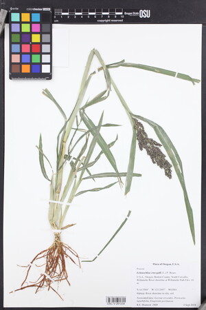 OSC-V-261234_lg.jpg |
 | Poaceae 16. Echinochloa crus-galli (L.) P. Beauv.U.S.A., Oregon, Morrow County: Marshy margin of south shore of Lake Umatilla reservoir on Columbia River, 8.5 air kilometers southwest of Crow Butte Island. Elev. 80 m. 45.8135° N, 119.959° W Datum: WGS 84. Coordinate Source: GPS. Damp shoreline, marsh edge, full sun, over basalt, with Schoenoplectus, Amorpha, Xanthium, Leersia. Common annual. USAC Columbia River Plant Survey. Origin: Introduced. Peter F. Zika 29056Aug 19, 2017WTU: 416504; WTU-V-035417 |  WTU-V-035417.jpg |
 | Poaceae 17. Echinochloa crus-galli (L.) P. Beauv.U.S.A., Oregon, Gilliam County: Near Blalock Canyon boat ramp, south shore of backwater of Lake Umatilla reservoir on Columbia River, north of Interstate 84. Elev. 80 m. 45.6962° N, 120.3724° W Coordinate Source: Specimen Label. Damp shoreline, full sun, over basalt, with Carex vulpinoidea, C. hystericina, Paspalum distichum. Occasional annual. USAC Columbia River Plant Survey. Reproductive state: Fertile. Origin: Introduced. Peter F. Zika 29049Aug 19, 2017WTU: 416714; WTU-V-036345 |  WTU-V-036345.jpg |
 | Poaceae 18. Echinochloa crus-galli (L.) P. Beauv.U.S.A., Oregon, Tillamook County: Highway 18, 11.2 air kilometers west of Grand Ronde. Elev. 197 m. 45.05569° N, 123.75179° W Datum: WGS 84. Moist roadside ditch in shady Douglas-fir forest. Associated taxa: Rubus ursinus, Daucus carota. Anthers ca. 0.8 mm. Reproductive state: Fertile. Origin: Introduced. R. E. Brainerd 2641Aug 16, 2017WTU: 426677; WTU-V-073990 |  WTU-V-073990.jpg |
 | Poaceae 19. Echinochloa crus-galli (L.) P. Beauv.U.S.A., Oregon, Douglas County: Roseburg; corner of Harvard Avenue and Bellows Street. Elev. 140 m. 43.21411° N, 123.35594° W Datum: WGS 84. Disturbed vacant area. Associated taxa: Trifolium repens, Chamaesyce. Awnless form. Reproductive state: Fertile. Origin: Introduced. R. E. Brainerd 2660Nov 17, 2017WTU: 426675; WTU-V-073988 |  WTU-V-073988.jpg |
 | Poaceae 20. Echinochloa crus-galli (L.) P. Beauv.Canada, British Columbia: Metro Vancouver, Burnaby, North Fraser Way, northeast of Wiggins Street. Elev. 4 m 49.191944°, -122.97491°. Industrial park landscaping, in deep ditch with Typha latifolia, Phalaris arundinacea. Large plants to 2 m tall, awns to 3.5 cm long, growing in muck and often still underwater after prolonged drought; the wetter the site the longer the awns in this case. UBC: V253556 Frank Lomer 10847Aug 31, 2017 |
 | Poaceae 21. Echinochloa crus-galli (L.) P. Beauv.U.S.A., Oregon, Tillamook County: Highway 18, 11.2 air kilometers west of Grand Ronde. Elev. 197 m. 45.05569° N, 123.75179° W Moist roadside ditch in shady Douglas fir. Anthers ca. 0.8 mm. Associated taxa: Rubus ursinus, Daucus carota. HPSU: 24769 Richard E. Brainerd 2641Aug 16, 2017 |  HPSU_024769.jpg |
 | Poaceae 22. Echinochloa crus-galli (L.) P. Beauv.United States, Oregon, Tillamook: Highway 18; 11.2 air kilometers west of Grand Ronde. Elev. 197 m. 45.05569°, -123.75179°. Datum: WGS84. Moist roadside ditch in shady Douglas-fir forest. HerbariumSpecimenDuplicate: Echinochloa crus-galli Anthers ca. 0.8 mm. https://oregonflora.org OSC-V-260424 R. E. Brainerd 2641Aug 16, 2017 | 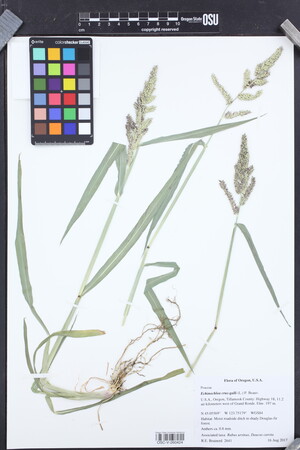 OSC-V-260424_lg.jpg |
 | Poaceae 23. Echinochloa crus-galli (L.) P. Beauv.United States, Oregon, Douglas: Highway 42, 1.7 km SW of downtown Winston. Elev. 165 m 43.11563°, -123.43487°. Datum: WGS84. Seasonally wet roadside ditch; partial shade. https://oregonflora.org OSC-V-263525 R.E. Brainerd 2662Nov 17, 2017 | 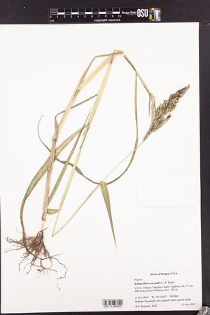 OSC-V-263525_lg.jpg |
 | Poaceae 24. Echinochloa crus-galli (L.) P. Beauv.United States, Oregon, Douglas: Roseburg; corner of Harvard Avenue and Bellows Street. Elev. 140 m. 43.21411°, -123.35594°. Datum: WGS84. Disturbed vacant area. HerbariumSpecimenDuplicate: Echinochloa crus-galli Awnless form. https://oregonflora.org OSC-V-263523 Richard E. Brainerd 2660Nov 17, 2017 | 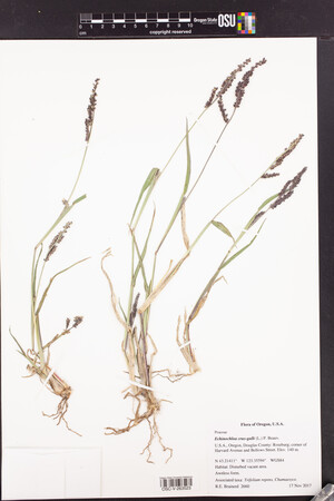 OSC-V-263523_lg.jpg |
 | Poaceae 25. Echinochloa crus-galli (L.) P. Beauv.U.S.A., Washington, King County: Mouth of Tibbetts Creek, at south end of Lake Sammamish. Site ID: BSL-1530. Elev. 10 m. 47.556719° N, 122.073731° W Datum: WGS 84. Coordinate uncertainty: 4 meters. Georeferenced by Ben Legler. Coordinate Source: GPS. Small, sandy creek delta with low cover of Cyperus bipartitus, Eleocharis acicularis, Juncus bufonius, backed by thickets of Phalaris arundinacea and Cornus stolonifera. Plants annual, 3-8 dm tall; inflorescences drooping, branches spike-like; floret awn 2 cm long or longer; plants locally common in moist silt, mixed with typical Echinochloa crus-galli with shorter awns. Reproductive state: Fertile. Ben Legler 14330Aug 24, 2016With Peter F. Zika WTU: 418940; WTU-V-041995 |  WTU-V-041995.jpg |
 | Poaceae 26. Echinochloa crus-galli (L.) P. Beauv.U.S.A., Washington, Pierce County: Storm water outflow below pond L003, near paintball parking, Joint Base Lewis-McChord. Elev. 85 m. 47.1038° N, 122.6009° W Coordinate Source: Specimen Label. Seasonally damp soil, full sun, with Eleocharis obtusa, Lythrum portula, Juncus acuminatus. Annual, leaves blue-green, occasional. Reproductive state: Fruits. Origin: Introduced. Peter F. Zika 28215Aug 12, 2016With Sarah Krock WTU: 412496; WTU-V-026901 |  WTU-V-026901.jpg |
 | Poaceae 27. Echinochloa crus-galli (L.) P. Beauv.U.S.A., Washington, King County: Mouth of Tibbetts Creek, south end of Lake Sammamish. Elev. 10 m. 47.556719° N, 122.073731° W Datum: WGS 84. Coordinate uncertainty: 4 meters. Coordinate Source: Specimen Label. Small, sandy creek delta with low cover of Cyperus bipartitus, Eleocharis acicularis, juncus bufonius, backed by thickets of Phalaris arundinacea and Cornus stolonifera. Annual, 3-8 dm tall; inflorescences drooping, branches spike-like; floret awn 2 cm long or longer; locally common in moist silt, mixed with typical Echinochloa crus-gallii with shorter awns. SRP: 67641 Ben Legler 14330Aug 24, 2016With P. Zika |  SRP067641.jpg |
 | Poaceae 28. Echinochloa crus-galli (L.) P. Beauv.United States, Oregon, Deschutes: Porcupine Dr. on north side of Pine Ridge Elementary school. Elev. 3840 ft. 44.02523°, -121.33073°. Around a post in small opening between parts of sidewalk. https://oregonflora.org OSC-V-261102 Cindy Roché 2016-41Oct 7, 2016 | 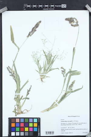 OSC-V-261102_lg.jpg |
 | Poaceae 29. Echinochloa crus-galli (L.) P. Beauv.U.S.A., Idaho, Canyon County: Near intersection of Lewis Ln. and Happy Valley Road, Nampa. Directly west of intersection near ditch/canal. Elev. 780 m. 43° 31\' 2.13" N, 116° 30\' 46.18" W Coordinate Source: Specimen Label. Disturbed habitat. Roadside gravel near bank by canal. SRP: 58045 Inna P. Smith 4-2015Aug 6, 2015 |  SRP058045.jpg |
 | Poaceae 30. Echinochloa crus-galli (L.) P. Beauv.U.S.A., Idaho, Valley County: Boise National Forest. Tyndall Meadow. Elev. 2063 m. 44.56621° N, 115.54448° W Reproductive state: Flowers. Origin: Introduced. Richard G. Olmstead 2015-13Jul 11, 2015With Sheila Olmstead, Audrey Ragsac WTU: 415609; WTU-V-033465 |  WTU-V-033465.jpg |
 | Poaceae 31. Echinochloa crus-galli (L.) P. Beauv.U.S.A., Washington, Thurston County: Tumwater Hill, intersection of 5th Avenue Southwest and Linwood. Elev. 180 ft. 47.007369° N, 122.910531° W Coordinate Source: Specimen Label. In joint between asphalt and concrete curb. Silt loam. With roadside weeds. Urbanized area. Locally common. Reproductive state: Flowers. Origin: Introduced. Regina Johnson 2015-002Jul 20, 2015WTU: 414354; WTU-V-031450 |  WTU-V-031450.jpg |
 | Poaceae 32. Echinochloa crus-galli (L.) P. Beauv.Canada, British Columbia: Metro Vancouver, Burnaby, Highway 1, north side, between Gaglardi Way west-bound entrance to Highway 1 and east-bound exit. Elev. 25 m 49.243333°, -122.91541°. Weedy landscaping strip planted with �native� plants; in mulch, with Convolvulus arvensis, Setaria viridis, Chenopodium album. Abundant annual weed, doing well in drought. UBC: V246957 Frank Lomer 9636Aug 9, 2015 |
 | Poaceae 33. Echinochloa crus-galli (L.) P. Beauv.U.S.A., Idaho, Canyon County: Ca 2.2 miles W of Star and 0.5 mile S of Highway 44. Elev. 2450 ft. UTM Zone 11, 537275E, 4837760N 43.693022°, -116.54325°. Datum: WGS 84. Coordinate uncertainty: 341 meters. Georeferenced by Pearl Brown. Coordinate Source: Digital Map. Small drainage pathway along margin of gravel mining pit; with Typha latifolia. Common. ID: 171490; ID176763 Michael Mancuso 4236Sep 9, 2015 |  ID176763.jpg + 1 more image |
 | Poaceae 34. Echinochloa crus-galli (L.) P. Beauv.U.S.A., Washington, Lewis County: Mt. Adams Veneer Company Mill Pond on east side of Road 25, 2.5 km due south of Randle. Site ID: BSL-1106. Elev. 259 m. 46.512712° N, 121.953542° W Datum: WGS 84. Coordinate uncertainty: 4 meters. Georeferenced by Ben Legler. Coordinate Source: GPS. Man-made pond, rimmed by Spirea douglasii and Typha latifolia, with Nuphar polysepala, Potamogeton natans, Iris pseudacorus. Small plants to 20 cm tall with decumbent stems, growing in now dry mud in parking area, with Lythrum hyssopifolia. Reproductive state: Fruits. Ben Legler 13345Sep 22, 2014With Sara Legler WTU: 407728; WTU-V-021904 |  WTU-V-021904.jpg |
 | Poaceae 35. Echinochloa crus-galli (L.) P. Beauv.U.S.A., Washington, Lewis County: Edge of parking area for boat launch at Taidnapum Park, east end of Riffe Lake. Site ID: BSL-1115. Elev. 254 m. 46.475531° N, 122.166124° W Datum: WGS 84. Coordinate uncertainty: 7 meters. Georeferenced by Ben Legler. Coordinate Source: GPS. Moist, gravelly soil between pavement and lawn, with scattered weeds. Inflorescences arching; plants locally common. Reference specimen for illustration in Revision of Flora of the Pacific Northwest WTU Herbarium, 2016. Reproductive state: Flowers and Fruits. Ben Legler 13376Sep 23, 2014With Sara Legler WTU: 408680; WTU-V-022459 |  WTU-V-022459.jpg |
 | Poaceae 36. Echinochloa crus-galli (L.) P. Beauv.Canada, British Columbia: Okanagan, Penticton, 150 m south-southeast of junction of Highway 97 and Fairview Road, Ellis Creek. Elev. 340 m 49.477778°, -119.59616°. Sandbar in slow flowing creek; growing with Juncus articulatus, Juncus ensifolius, Eragrostis minor, Eragrostis multicaulis, Gnaphalium uliginosum, Lythrum salicornia seedlings. Frequent and scattered on little sandbar used by ducks. UBC: V242261 Frank Lomer 9050Sep 16, 2014 |
 | Poaceae 37. Echinochloa crus-galli (L.) P. Beauv.U.S.A., Alaska: Fairbanks. 64.837778°, -147.71638°. Datum: WGS 84. Coordinate uncertainty: 13749 meters. Georeferenced by Natalie Konig. Coordinate Source: GeoLocate. Contaminant in potted plant, growing up against a house. Specimen from homeowner, turned in to UAF Cooperative Extension Service. UAAH: 11988 Unknown s.n.Sep 9, 2014 |  UAAH_011988.jpg |
 | Poaceae 38. Echinochloa crus-galli (L.) P. Beauv.U.S.A., Alaska: Fairbanks. 64.837778°, -147.71638°. Datum: WGS 84. Coordinate uncertainty: 13749 meters. Georeferenced by Natalie Konig. Coordinate Source: GeoLocate. Contaminant in potted plant, growing up against a house. Specimen from homeowner, turned in to UAF Cooperative Extension Service. UAAH: 11989 Unknown s.n.Sep 9, 2014 |  UAAH_011989.jpg |
 | Poaceae 39. Echinochloa crus-galli (L.) P. Beauv.U.S.A., Idaho, Owyhee County: At edge of Snake River, park along Rt. 55 near bridge, Marsing. Elev. 680 m. 43.549221° N, 116.80176° W Emergent portion 6\' tall; rooted in water. SRP: 80047 Michael A. Vincent 16803Jul 24, 2014With Mary W. Vincent |  SRP080047.jpg |
 | Poaceae 40. Echinochloa crus-galli (L.) P. Beauv.U.S.A., Washington, Cowlitz County: Island Park Recreation Area on north side of Lewis River along Highway 503. Elev. 14 m. 45.93921° N, 122.68172° W Datum: WGS 84. Coordinate uncertainty: 100 meters. Georeferenced by Maria Yousoufian. Coordinate Source: GPS. Riverbank with silty and gravelly areas; island in middle of river with Phalaris arundinacea and Lotus corniculatus. Locally common in silty soil on north riverbank. Reproductive state: Fruits. Origin: Introduced. Cathy Maxwell 13-70Aug 28, 2013WTU: 409056; WTU-V-023039 |  WTU-V-023039.jpg |
  | Poaceae 41. Echinochloa crus-galli (L.) P. Beauv.U.S.A., Idaho, Elmore County: North Fork Boise River, Slopes along reservoir that had been under water earlier in the year. Elev. 3353 ft. 43° 37.705\' 115° 49.375\' Coordinate Source: Specimen Label. Invalid coordinates (located outside county bounds). SRP: 53488 J. F. Smith 11416Aug 7, 2013 |  SRP053488.jpg |
 | Poaceae 42. Echinochloa crus-galli (L.) P. Beauv.U.S.A., Idaho, Elmore County: North Fork Boise River. 43° 43.4\' 115° 36.656\' Coordinate Source: Specimen Label. Inverted longitude. Scree Slope and Pinus ponderosa forest, Ninmeyer hot springs, old farmstead. SRP: 53489 J. F. Smith 11375Aug 7, 2013 |  SRP053489.jpg |
 | Poaceae 43. Echinochloa crus-galli (L.) P. Beauv.Canada, British Columbia: Metro Vancouver, Surrey, 160 m due northeast of King George Boulevard & 72 Avenue. Elev. 5 m 49.134306°, -122.79883°. Landfilled field in agricultural area. Low depression with Madia glomerata, Portulaca oleracea. Large erect bright green plants; leaves to 22 mm wide; few plants like this, others of this species low; spreading; purplish-red tinged; common at site. UBC: V241027 Frank Lomer 8571Aug 25, 2013 | 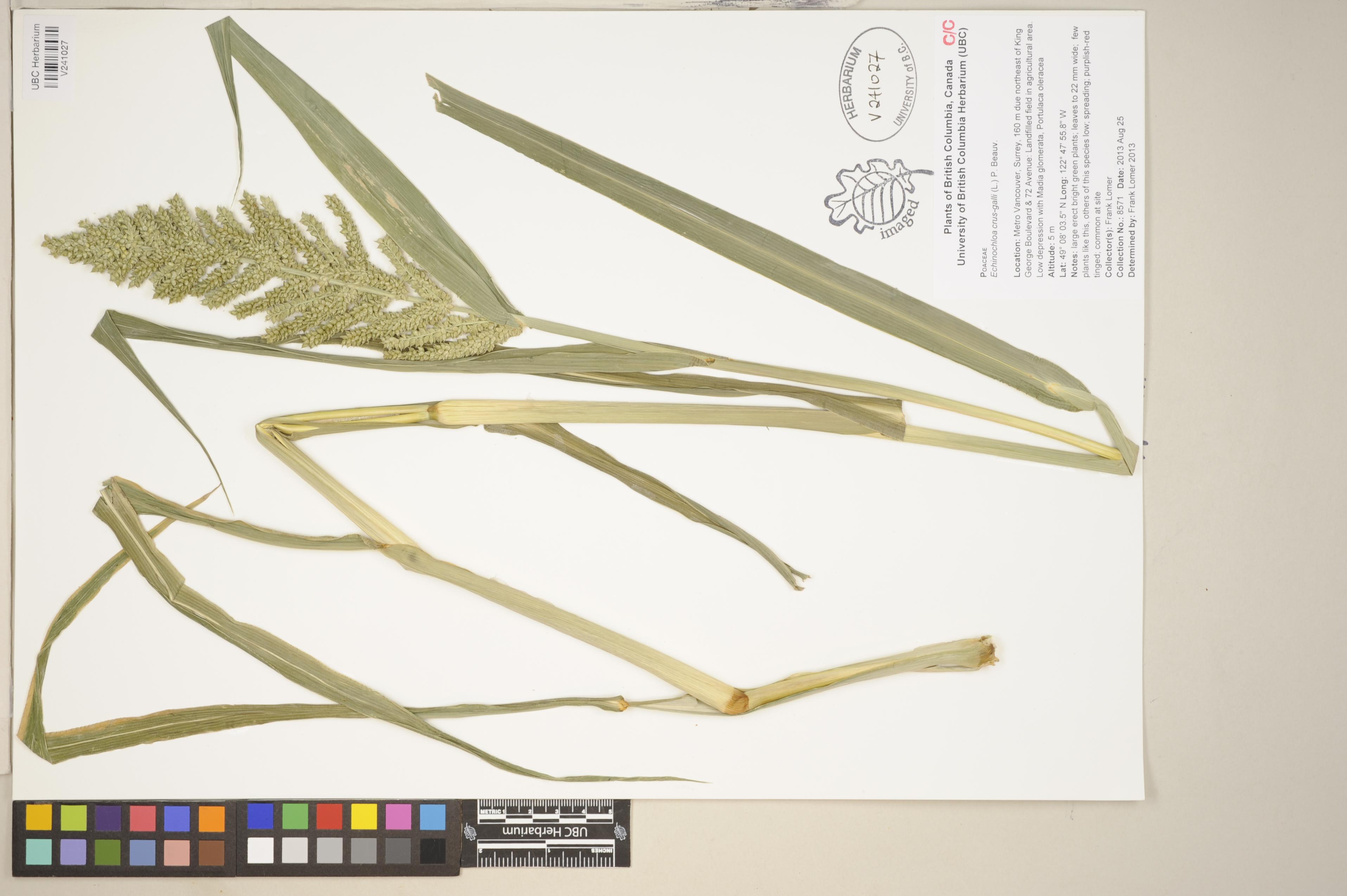 V241027.jpg |
 | Poaceae 44. Echinochloa crus-galli (L.) P. Beauv.U.S.A., Washington, Chelan County: Columbia River. Riverfront Park in Wenatchee, Walla Walla swimming area, mud flat near the water by a foot bridge. Elev. 700 ft. T23N R20E S34 47.4432°, -120.3148°. Datum: NAD 27. Coordinate uncertainty: 805 meters. Georeferenced by Ben Legler. Coordinate Source: TRS2LL. Sparse vegetation. Clumps of Poa annua, Juncus, Coryopsis, Bidens, Polygonum. 5% slope north aspect. Reproductive state: Flowers and Fruits. Origin: Introduced. P. Camp 2305Oct 19, 2011WTU: 398905; WTU-V-007945 |  WTU-V-007945.jpg |
 | Poaceae 45. Echinochloa crus-galli (L.) P. Beauv.Canada, Saskatchewan: Saskatoon, Kiwanis Park, South Saskatchewan River. Elev. 475 m 52.12647°, -106.657° Wet silty mud along disturbed river flat with Typha latifolia, tomato plants, broccoli, and Echinocystis lobata. Only place seen. 4 duplicates. B.A. Bennett 11-0451Aug 24, 2011BABY-07891; Genetic barcoding: CCDB-18344-C5 |  BABY-07891.jpg |
 | Poaceae 46. Echinochloa crus-galli (L.) P. Beauv.U.S.A., Oregon, Linn County: 0.25 mile northwest of Riverside Drive and Stellmacher Drive; 3 air miles west-southwest of downtown Albany. Elev. 200 ft. UTM Zone 10, 487244E, 4940422N 44.617036°, -123.16077°. Datum: WGS 84. Georeferenced by Dan Post. Coordinate Source: Calc. from UTM. Disturbed wetland swale. With Setaria viridis, Sorghum halepense, Lolium multiflorum, Abutilon theophrasti. Reproductive state: Fruits. Origin: Introduced. WTU: 388013 R.E. Brainerd 1783Nov 4, 2010 |
 | Poaceae 47. Echinochloa crus-galli (L.) P. Beauv.Canada, British Columbia: Grand Forks, Como Road, east side, 230 m north of Carson Road. Elev. 527 m 49.0095°, -118.44230°. Corner margin of agricultural field, in rich disturbed soil with Amaranthus powellii. Robust plants to 160 cm tall. UBC: V234945 Frank Lomer 7563Oct 4, 2010 |
 | Poaceae 48. Echinochloa crus-galli (L.) P. Beauv.U.S.A., Washington, Snohomish County: Warm Beach Camp Ground, Stanwood. 48.18745°, -122.34993°. Datum: WGS 84. Coordinate uncertainty: 850 meters. Georeferenced by Maria Yousoufian. Coordinate Source: Digital map. Edge of horse stable cleanings. Reproductive state: Fruits. Origin: Introduced. Clayton Haberman s.n.Aug 23, 2010WTU: 402426; WTU-V-010786 |  WTU-V-010786.jpg |
 | Poaceae 49. Echinochloa crus-galli (L.) P. Beauv.U.S.A., Montana, Valley County: Lake Gabel (dry), S of Hinsdale Road, ca 8 air mi WSW of Lighthouse Hill, ca 32 air mi NNE of Hinsdale; ca 48.5 air mi NNW of Glasgow. Elev. 2550-2570 ft. 48° 51\' 2.4" N, 106° 58\' 35" W Coordinate Source: Specimen Label. Dried or drying mud on reservoir bottom. MONTU: 162933 Joseph L. M. Charboneau 3358Aug 19, 2010 |  MONTU_162933.jpg |
 | Poaceae 50. Echinochloa crus-galli (L.) P. Beauv.U.S.A., Idaho, Ada County: Lower Hulls gulch Reserve in foothills NE of Boise, quarry pond north of Sunset Peak Road opposite Foothills Learning Center. Elev. 880 m. 43.642° N, 116.187° W Coordinate Source: Specimen Label. Near pond outlet. Rare and local. SRP: 67126 Barbara Ertter 20656Sep 25, 2010 |  SRP067126.jpg |


