Terrain
Road Map
Satellite
Hybrid
Terrain

 | Brassicaceae 1. Cardamine angulata Hook.U.S.A., Washington, Thurston County: Yelm Park, Nisqually River. Elev. 300 ft. 46.976° N, 122.644° W Datum: WGS 84. Coordinate Source: GPS. Lowland riparian forest. Sandy loam soil. With Pseudotsuga menziesii, Populus trichocarpa, Alnus rubra, Acer macrophyllum, Fraxinus latifolia. Uncommon. Reproductive state: Flowers. Origin: Native. Regina Johnson 2023-016Apr 22, 2023WTU: 460571; WTU-V-116809 |  WTU-V-116809.jpg |
  | Brassicaceae 2. Cardamine angulata Hook.U.S.A., Washington, Grays Harbor County: Tidally influenced alder forest located off Peel’s Slough of the Chehalis River near Montesano. 47.958772° N, 123.634956° W Invalid coordinates (located outside county bounds). Moist, full shade, fresh water tidal surge plain wetland/riparian shrub-forest Common, forb, rhizomes, erect; only fruits. Reproductive state: Fruits. Origin: Native. Patricia Johnson NWC21-WA-10037-U28Jun 8, 2021WTU: 426818; WTU-V-074105 |  WTU-V-074105.jpg |
 | Brassicaceae 3. Cardamine angulata Hook.U.S.A., Oregon, Clackamas County: Clackamas River. Bonnie Lure State Natural Area. Elev. 250 ft. 45.347994°, -122.38286°. Datum: WGS 84. Georeferenced by Dominic Maze. Coordinate Source: Digital Map. Boggy river side. With partial Populus, Fraxinus, Acer macrophyllum overstory. Occasional Reproductive state: Flowers. Origin: Native. HPSU: 23505 Dominic Maze 1761May 22, 2021 |  HPSU_023505.jpg |
 | Brassicaceae 4. Cardamine angulata Hook.U.S.A., Washington, Cowlitz County: Highway 4 opposite of Willow Grove Island, north side of highway. Elev. 5 m. 46.1885° N, 123.09677° W Datum: WGS 84. Coordinate uncertainty: 20 meters. Coordinate Source: GPS. Forested wetland with Lysichiton americanus, Athyrium-filix-femina, and Dicentra formosa common. Uncommon in saturated soil; corollas white. Reproductive state: Flowers and Fruits. Origin: Native. David Giblin 8051Apr 29, 2021WTU: 429636; WTU-V-087972 |  WTU-V-087972.jpg |
 | Brassicaceae 5. Cardamine angulata Hook.United States, Washington, Grays Harbor: Pacific Coast Range: Preacher Slough Trail (old railroad bed) along south boundary of Chehalis River Surge Plain Natural Area Preserve, 3 air miles SW of Montesano. T17N R8W S23 NE4 NW4 SW4. Elev. 20 ft 46.94352°, -123.65225°. Edge of trail in Alnus rubra, Picea sitchensis, Tsuga heterophylla, Acer macrophyllum, and Sambucus racemosa forest. Understory of Rubus ursinus, Tellima grandiflora, Rubus spectabilis, Claytonia sibirica, and Ranunculus repens. Soil loamy clay, moist. HerbariumSpecimenDuplicate: Cardamine angulata Rhizomatous perennial. Uncommon. https://intermountainbiota.org WS: 400658; WS008914 Walter Fertig 34440May 10, 2020 |  WS008914_1708562487_lg.jpg |
 | Brassicaceae 6. Cardamine angulata Hook.United States, Washington, Grays Harbor: Pacific Coast Range: Preacher Slough Trail (old railroad bed) along south boundary of Chehalis River Surge Plain Natural Area Preserve, 3 air miles SW of Montesano. T17N R8W S23 NE4 NW4 SW4. Elev. 20 ft 46.94352°, -123.65225°. Edge of trail in Alnus rubra, Picea sitchensis, Tsuga heterophylla, Acer macrophyllum, and Sambucus racemosa forest. Understory of Rubus ursinus, Tellima grandiflora, Rubus spectabilis, Claytonia sibirica, and Ranunculus repens. Soil loamy clay, moist. https://intermountainbiota.org WS: 411396; WS036475 Walter Fertig 34440May 10, 2020 |  WS036475.JPG |
 | Brassicaceae 7. Cardamine angulata Hook.U.S.A., Oregon, Columbia County: Scapoose watershed, Gourley Creek off Otto Miller Rd. 45.735684° N, 122.958735° W Coordinate Source: Specimen Label. Forested Creekside and wet slopes. Reproductive state: Flowers. HPSU: 20748 Dominic Maze 780Apr 5, 2018 |  HPSU_020748.jpg |
 | Brassicaceae 8. Cardamine angulata Hook.U.S.A., Oregon, Clackamas County: Barton. 45.384199° N, 122.413407° W Coordinate Source: Specimen Label. Riparian forest. Small population. HPSU: 19288 Jeffrey T. Lesh 238Apr 27, 2017 |  HPSU_019288.jpg |
 | Brassicaceae 9. Cardamine angulata Hook.U.S.A., Oregon, Clackamas County: S of Estacada in Mount Hood National Forest. 45.114772° N, 122.281801° W Datum: WGS 84. Coordinate Source: Specimen Label. Forest roadside ditch. Reproductive state: Flowers and Fruits. Origin: Native. Jeffrey T. Lesh 395Aug 17, 2017WTU: 420339; WTU-V-044883 |  WTU-V-044883.jpg |
 | Brassicaceae 10. Cardamine angulata Hook.U.S.A., Oregon, Clackamas County: Mt. Hood National Forest, off NF-45 900 air km NW of junction with NF-4540. 45.114772° N, 122.2818801° W Coordinate Source: Specimen Label. Forest roadside ditch. Reproductive state: Fruits. Origin: Native. HPSU: 20289 Jeffrey T. Lesh 395Aug 17, 2017 |
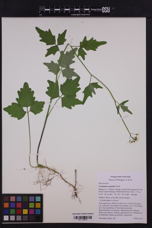
 | Brassicaceae 11. Cardamine angulata Hook.United States, Oregon, Benton: Along a creek intersecting FR 700, Soap Creek Drainage, McDonald Forest. Elev. 175 44.642911°, -123.3258°. Georeferenced by [automated process-OregonFlora/OSU Herb]. Coordinate Source: OrlookId: 125011, StateProvince: Oregon, County: Benton, LocName: Lat 44 Deg 38 Min 34.481 Sec; Lon -123 Deg 19 Min 32.88 Sec. OregonFlora 1994-2020 methodology. Rocky soil at the creek margins. Mitella caulescens, Petasites frigidus var. palmatus, Geranium robertianum, Acer circinatum, Acer macrophyllum, Polystichum munitum, Maianthemum racemosum, Maianthemum stellatum, Rubus parviflorus, Tolmiea diplomenziesii, Delphinium trolliifolium, Rubus spectabilis, Equisetum https://oregonflora.org OSC-V-255876 Alexander Abair 201May 9, 2017 |  OSC-V-255876_lg.jpg |
 | Brassicaceae 12. Cardamine angulata Hook.U.S.A., Washington, Lewis County: Ceres Hill Road, at a switchback on slope near west end of road, 15 air km southwest of Chehalis. Site ID: BSL-1152. Elev. 170 m. 46.61591° N, 123.15625° W Datum: WGS 84. Coordinate uncertainty: 4 meters. Coordinate Source: GPS. Wet roadside ditch in mixed conifer-deciduous forest, with Equisetum telmateia, Rubus spectabilis. Petals white; stems erect; plants with branching rhizomes, scattered in wet soil of ditch. Reproductive state: Flowers and Fruits. Ben Legler 13482May 8, 2015With Sara Legler WTU: 410372; WTU-V-024459 |  WTU-V-024459.jpg |
 | Brassicaceae 13. Cardamine angulata Hook.U.S.A., Washington, Thurston County: Capitol State Forest: along C-Line Road. Site ID: BSL-0974. Elev. 390 m. 47.01112° N, 123.11919° W Datum: WGS 84. Coordinate uncertainty: 12 meters. Georeferenced by Ben Legler. Coordinate Source: GPS. Wet ditch under edge of conifer forest. Petals white; plants rhizomatous, common in saturated soil. Photographed. Reproductive state: Flowers. Ben Legler 12996May 31, 2014WTU: 428376; WTU-V-084068 |  WTU-V-084068.jpg |
 | Brassicaceae 14. Cardamine angulata Hook.U.S.A., Alaska: [locality and coordinates withheld; status in Alaska: S1S2 (Imperiled; ACCS)]. Site ID: F1.4-003. Elev. 86 m. Forested wetland on small floodplain in flood courses and pools; mostly dry with several small pools still with water UAAH: 8986 Timm Nawrocki TWN2014-122Jun 29, 2014With Casey Greenstein |  |
 | Brassicaceae 15. Cardamine angulata Hook.U.S.A., Alaska: [locality and coordinates withheld; status in Alaska: S1S2 (Imperiled; ACCS)]. Site ID: F1.4-003. Elev. 86 m. Forested wetland on small floodplain in flood courses and pools; mostly dry with several small pools still with water UAAH: 9405 Timm Nawrocki TWN2014-122Jun 29, 2014With Casey Greenstein |  |
 | Brassicaceae 16. Cardamine angulata Hook.U.S.A., Alaska: [locality and coordinates withheld; status in Alaska: S1S2 (Imperiled; ACCS)] Elev. 86 m. Forested wetland on small floodplain in flood courses and pools; mostly dry with several small pools still with water UAAH: 9417 Timm Nawrocki TWN2014-122Jun 29, 2014 |
 | Brassicaceae 17. Cardamine angulata Hook.United States of America, Oregon, Multnomah County: Powell Butte Nature Park: Just upstream from Deardorff Creek or Johnson Creek. Elev. 600 45.484727°, -122.50908°. Datum: WGS84. HOYT: 2016-201/1 Mart Hughes Jun 6, 2012 |
 | Brassicaceae 18. Cardamine angulata Hook.U.S.A., Oregon, Multnomah County: Along the Wildwood Trail 200-1000 yards past the entrance to the Wildwood Trail at NW Upshur Street along Balch Creek. Elev. 75 ft. 45.533043°, -122.71455°. Datum: WGS 84. Coordinate uncertainty: 287 meters. Georeferenced by Hannah Machiorlete. Coordinate Source: Digital Map. Heavily traveled nature trail in a large urban park. Flowers white. HPSU: 19612 Amy Blettel 40May 12, 2009 |  HPSU_019612.jpg |
 | Brassicaceae 19. Cardamine angulata Hook.U.S.A., Oregon, Clackamas County: 4 mi. S of West Linn, 1.5 mi. S of Willamette Park, Willamette Narrows. Elev. 50 45° 18\' 53" N, 122° 40\' 3" W Coordinate uncertainty: 500 meters. Georeferenced by Char Corkran. Coordinate Source: Specimen Label. [no habitat data] HPSU: 21198 Celeste Coulter s.n.2007 |  HPSU_021198.jpg |
 | Brassicaceae 20. Cardamine angulata Hook.U.S.A., Washington, Clark County: Washougal, about 6 miles north of Highway 14; 512 NE 302nd Ave, 98671. 45° 37\' 32.6" N, 122° 21\' 49" W A marginally shaded, grassy area, about 10 ft from a stream; assoc. species: grasses, snowberry and pines. A perennial herb standing about 36 cm tall; a single stem arising from base with lobed trifoliate leaves; inflorescence is a raceme of white flowers. Plant is distributed sporadically throughout grass. HPSU: 12408 Eden Addis 19Jun 4, 2006 |  HPSU003249.jpg |
 | Brassicaceae 21. Cardamine angulata Hook.U.S.A., Washington, Clark County: WSU Vancouver campus, nature trail. Elev. 63 m. 45° 44\' 6.3" N, 121° 37\' 45.1" W Datum: WGS 84. Coordinate uncertainty: 218 meters. Georeferenced by John Christy. Coordinate Source: Digital Map. Coordinates on label incorrect. Riparian zone of Mill Creek. 70 cm tall from rhizomes; leaves trifoliate, leaflets palmately lobed, mostly on stalk; flowers white and arranged as a raceme. Associated species: Glechoma hederacea, Tellima grandiflora, Tolmiea menziesii, Hydrophyllum tenuipes, Dicentra formosa, Douglas fir, western red cedar, sword fern, bracken fern, stinging nettle; perennial herb up to 70 cm tall from rhizomes, mustard oils. HPSU: 12409 Ashley Van Hoose 17May 19, 2006 |  HPSU003250.jpg |
 | Brassicaceae 22. Cardamine angulata Hook.U.S.A., Oregon, Tillamook County: Along stream at Short Sands; trail from parking to beach. Moist forest and stream banks; low elevation. Height: 40 cm; fruit is a silique; perennial with slender rhizomes; flower color: white. Associated species: Polystichum munitum, Athyrium filixfemina, Symphoricarpos albus, Pseudotsuga menziesii. HPSU: 14028 Adriana Rivadereira s.n.Apr 20, 2005 |  HPSU003243.jpg |
 | Brassicaceae 23. Cardamine angulata Hook.U.S.A., Oregon, Lincoln County: YWCA Camp Westwind, about 3 miles west of Hwy 101 at end of Fraser Road (service road), about 9 miles north of Lincoln City; on Fraser Road. T06S R11W S23 In very moist sitka spruce habitat; coast range ecoregion. Wood bittercress. LINF: 4006 Elizabeth Fliszar 23May 7, 2005 |  LINF004006.jpg |
 | Brassicaceae 24. Cardamine angulata Hook.United States, Washington, Thurston: Scatter Creek State Wildlife Area, west segment, about 0.8 kilometers north of main entrance at point where powerline bisects oak grove. 46.80139°, -123.09806°. Associated taxa: Montia, Cardamine, Rosa, Phalaris, Circium. https://intermountainbiota.org WS: 368891 Brenda Tom s.n.May 15, 2005With Ronald Tooner |
 | Brassicaceae 25. Cardamine angulata Hook.U.S.A., Washington, Wahkiakum County: 4 miles north of Oneida, along Deep River Valley Road ca. 1.5 miles north of junction with Anderson road. Elev. 50 ft. 46° 22\' 43.5" N, 123° 40\' 8.9" W Coordinate uncertainty: 200 meters. Wet deciduous forest along small stream, dominated by Alnus rubra, Rubus spectabilis, Lysichiton americanum. Petals white, ca 9 mm; uncommon along creek. Reproductive state: Flowers. Origin: Native. WTU: 354360 Ben Legler 546Jun 1, 2003 |
 | Brassicaceae 26. Cardamine angulata Hook.U.S.A., Washington, Pacific County: SW side of Route 6, ca. 1.5 miles SE of Raymond. Elev. 164 ft. 46° 40.2\' N, 123° 41.7\' W; T14N R8W S29 Wet ditch, full sun with Scirpus microcarpus, Equisetum telmateia, Athyrium filix-femina, grasses. Rhizomatous, rotate white flowers, petals 9-10mm long; common. Origin: Native. WTU: 353887 P. F. Zika 18248Apr 23, 2003 |
 | Brassicaceae 27. Cardamine angulata Hook.U.S.A., Washington, Pacific County: The Nature Conservancy\'s Ellsworth Creek Preserve, 5 miles northwest of Naselle along upper Ellsworth Creek. Elev. 180 ft. 46° 22\' 59.8" N, 123° 52\' 44.3" W Datum: WGS 84. Coordinate uncertainty: 2000 meters. Georeferenced by Jim Duemmel. Coordinate Source: Digital Map. Old growth forest on east side and young second growth on west side; with Picea sitchensis, Tsuga heterophylla, Alnus rubra; over sandstone bedrock. Large white flowers approximately 3 mm; common on gravel bars of creek. Reproductive state: Flowers & Fruits. Origin: Native. WTU: 356850 Ben Legler 442May 31, 2003 |
 | Brassicaceae 28. Cardamine angulata Hook.U.S.A., Washington, Pacific County: The Nature Conservancy\'s Ellsworth Creek Preserve. Waypoint #36. Along trail in forest tract just above logging spur road. Elev. 161 ft. 46° 23.68\' N, 123° 53.054\' W Creekside along Ellsworth Creek. Reproductive state: Flowers & Fruits. Origin: Native. WTU: 357526 Richard G. Olmstead 2003-47May 31, 2003 |
 | Brassicaceae 29. Cardamine angulata Hook.U.S.A., Washington, Pacific County: Southwest side of Route 1010, south shore of Willapa River, circa 2 miles west of South Bend. Pottter Slough. Elev. 6 ft. 46° 40.9\' N, 123° 49.5\' W; T14N R9W S20 With Alnus rubra, Cytisus scoparius. White rotate fragrant flowers, petals 13-14 millimeters; rhizome shallow, green, 31 centimeters where broken; most leaves with 5 leaflets, only disatl with 3 \; sunny wet depression. [Sheet 1 of 2]. Reproductive state: Flowers & Fruits. Origin: Native. WTU: 354726 P. F. Zika 18246Apr 23, 2003 |
 | Brassicaceae 30. Cardamine angulata Hook.U.S.A., Washington, Pacific County: Southwest side of Route 1010, south shore of Willapa River, circa 2 miles west of South Bend. Pottter Slough. Elev. 6 ft. 46° 40.9\' N, 123° 49.5\' W; T14N R9W S20 With Alnus rubra, Cytisus scoparius. White rotate fragrant flowers, petals 13-14 millimeters; rhizome shallow, green, 31 centimeters where broken; most leaves with 5 leaflets, only disatl with 3 \; sunny wet depression. [Sheet 2 of 2]. Reproductive state: Flowers & Fruits. Origin: Native. WTU: 354332 P. F. Zika 18246Apr 23, 2003 |
 | Brassicaceae 31. Cardamine angulata Hook.U.S.A., Oregon, Columbia County: Stonebrook Road 0.2 miles from Leberg Road, between Warren and Scappoose. Bank of Honeyman Creek. 45° 47.7\' N, 122° 53\' W; T3N R1W S36 Moist soil, shade of Alnus ribra, with Urtica, Equisetum temateia, Athyrium filix-femina, hydrophyllum, Oxalis, Phalaris. Rhizome horizontal, 15-30 centimeters x 2-2.2 millimeters thick; white flowers, petals 9-10 millimeters long, rotate, 6 stamens (selfs). Reproductive state: Flowers. Origin: Native. WTU: 354582 Peter F. Zika 18228Apr 21, 2003 |
 | Brassicaceae 32. Cardamine angulata Hook.U.S.A., Oregon, Columbia County: Stonebrook Road 0.2 miles from Leberg Road, between Warren and Scappoose. Bank of Honeyman Creek. 45° 47.7\' N, 122° 53\' W; T3N R1W S36 Moist soil, bank of creek, shade of Alnus rubra, with Urtica, Equisetum temateia, Athyrium filix-femina, Hydrophyllum, Oxalis, Phalaris. Rhizome horizontal, 15-30 centimeters x 2-2.2 millimeters thick; white flowers, petals 9-10 millimeter long, rotate, 6 stamens (selfs). Reproductive state: Flowers. Origin: Native. WTU: 365233 Peter F. Zika 18228Apr 21, 2003 |
 | Brassicaceae 33. Cardamine angulata Hook.United States, Washington: Pacific County. The Nature Conservancy’s Ellsworth Creek Preserve. Waypoint #36. Along trail in forest track just above logging spur road. Elev. 49 m/161 ft 46.394667°, -123.88423°. Creekside along Ellsworth Creek. Fide: H&C. UBC: V222415 Richard G. Olmstead 2003-47May 31, 2003 |
 | Brassicaceae 34. Cardamine angulata Hook.United States, Washington, Pacific: The Nature Conservancy\'s Ellsworth Creek Preserve; waypoint #36; along trail in forest tract just above logging spur road; creekside along Ellsworth Creek. Elev. 161 ft. 46.394667°, -123.88423°. Georeferenced by [automated process-OregonFlora/OSU Herb]. Coordinate Source: OrlookId: 117336, StateProvince: Washington, County: Pacific, LocName: Lat 46 Deg 23.68 Min; Lon -123 Deg 53.054 Min. OregonFlora 1994-2020 methodology. Along trail in forest tract just above logging spur road; creekside along Ellsworth Creek. HerbariumSpecimenDuplicate: Cardamine angulata https://oregonflora.org Richard G. Olmstead 2003-47May 31, 2003OSC: Accession Number: OSC215185 |
 | Brassicaceae 35. Cardamine angulata Hook.United States, Washington, Pacific: The Nature Conservancy\'s Ellsworth Creek Preserve, 5 miles northwest of Naselle along upper Ellsworth Creek. Elev. 180 ft. 46.383278°, -123.87897°. Georeferenced by [automated process-OregonFlora/OSU Herb]. Coordinate Source: OrlookId: 117343, StateProvince: Washington, County: Pacific, LocName: Lat 46 Deg 22 Min 59.8 Sec; Lon -123 Deg 52 Min 44.3 Sec. OregonFlora 1994-2020 methodology. Old growth forest on east side and young second growth on west side; over sandstone bedrock; on gravel bars of creek. HerbariumSpecimenDuplicate: Cardamine angulata https://oregonflora.org Ben Legler 442May 31, 2003OSC: Accession Number: OSC215055 |
 | Brassicaceae 36. Cardamine angulata Hook.U.S.A., Washington, JEFFERSON County: Permanent plot: Queets 2 (west of Ranger Station) Elev. 270 ft. UTM Zone 10, 422500E, 5274000N; T.24 . __R. 10 . __Sec. 2. __ __ __ Alder flatSubstrate: sandLandform: flood plainWhite flower when fresh 1 plant w/ leaves, flowers, roots; flower in packet.; Det. BUG 3/12/2008 OLYM-00547; OLYM 32927 E. Arnheim s.n.Jun 11, 2002 |
  | Brassicaceae 37. Cardamine angulata Hook.U.S.A., Washington, Columbia County: Southeast of town of Clatskanie, between Swedentown Road and Keystone Creek. Elev. 129 m. 46.071833°, -123.1428333° Invalid coordinates (located outside county bounds). With Alnus, Acer, Sambucus, Tellima. Origin: N. NY: 01158152 D. E. Atha May 3, 2000 |
 | Brassicaceae 38. Cardamine angulata Hook.U.S.A., Washington, Pacific County: Ellsworth Creek watershed. T10N R10W S2 46.382778°, -123.88111°. Datum: NAD 27. Coordinate uncertainty: 1000 meters. Georeferenced by WTU Staff. Coordinate Source: Georeferenced. Old-growth forest (Tsuga heterophylla, Thuja plicata, Picea sitchensis), with Gaultheria shallon, Blechnum spicant, Oxalis oregana, Lysichiton americanum. Reproductive state: Fruits. Origin: Native. WTU: 339599 Eliza Habegger 652Jul 1, 1999With John Floberg |
 | Brassicaceae 39. Cardamine angulata Hook.Canada, British Columbia, Queen Charlotte Islands: [locality and coordinates withheld; status in British Columbia: S2S3 (Rare, Blue List; BCCDC)] Elev. 50 m Population of ca. 60 plants. Conservation Status:CDC: Red. V172048 Frank Lomer 97531Aug 23, 1997With N. Grove |
 | Brassicaceae 40. Cardamine angulata Hook.Canada, British Columbia, Vancouver Island: [locality and coordinates withheld; status in British Columbia: S2S3 (Rare, Blue List; BCCDC)] Elev. 5 m Conservation Status:CDC: Red. V186519 Hans Roemer 97006May 1, 1997 |
 | Brassicaceae 41. Cardamine angulata Hook.U.S.A., Washington, Pierce County: Fort Lewis, Nisqually River east of Carter woods approx. 1 mile S of fish hatchery. Elev. 98 ft. 525900E, 5207300N 47.01266°, -122.66057°. Datum: WGS 84. Coordinate uncertainty: 500 meters. Georeferenced by WTU Staff. Coordinate Source: GeoLocate. In woods adjoining spring/creek. Aspect 240 degrees, slope 10%. Substrate sandy loam or gravel. Assoc. spp: Athyrium felix-femina, Acer circinatum, Rubus parviflorum, Montia siberica, Equisetum telmaetia, Pseudotsuga menziezii, Oxalis trillifolia, Mertensia platyphylla, Lysichitum americanum, Montia sibirica, Dicentra formosa. Plants scattered/common on wet gravel sites wherever springs exit hillsides. Reproductive state: Flowers & Fruits. Origin: Native. WTU: 329977 David Thysell 707Apr 28, 1994 |
 | Brassicaceae 42. Cardamine angulata Hook.United States, Washington, Pierce: Along spring/creek on east side of Nisqually River east of Carter woods approximately 1 mile south of fish hatchery. Elev. 30 Aspect 240 degrees; slope 10%; substrate gravel; on wet gravel sites wherever springs exit hillsides. HerbariumSpecimenDuplicate: Cardamine angulata https://oregonflora.org David Thysell 707Apr 28, 1994OSC: Accession Number: OSC177958 |
 | Brassicaceae 43. Cardamine angulata Hook.Canada, British Columbia: [locality and coordinates withheld; status in British Columbia: S2S3 (Rare, Blue List; BCCDC)] In heavy humus litter, densely shaded coniferous forest. UBC: V208186 A. R. McCutcheon s.n.Jul 5, 1993 |
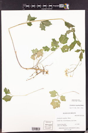
 | Brassicaceae 44. Cardamine angulata Hook.United States, Oregon, Lane: N of Florence, Lily Lake. 44.0925°, -124.1153°. Georeferenced by [automated process-OregonFlora/OSU Herb]. Coordinate Source: OrlookId: 8821, StateProvince: Oregon, County: Lane, LocName: Lily Lake, Lane Co.. OregonFlora 1994-2020 methodology. None. https://oregonflora.org Aaron I. Liston; Aaron Liston 863Apr 2, 1992With J.A. Wheeler OSC-V-021810; Accession Number: OSC178549 |  OSC-V-021810_lg.jpg |
 | Brassicaceae 45. Cardamine angulata Hook.U.S.A., Washington, CLALLAM County: Dungeness River, 1 mi. W of Sequim Elev. 275 ft. moist riparian forest 1 plant w/ roots, leaves, and flowers, and 2 plants w/ roots and leaves; Det. TISCH, EDWARD L. OLYM-00715; OLYM 38528 EDWARD L. TISCH s.n.May 19, 1991 |
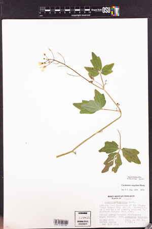
 | Brassicaceae 46. Cardamine angulata Hook.United States, Oregon, Lincoln: Foothills of the Oregon Coast Range; Nashville, ca 3 air mi W of summit, adjacent to Southern Pacific Rail Line. Elev. 700 ft. 44.64419°, -123.64805°. Datum: NAD83. Georeferenced by [automated process-OregonFlora/OSU Herb]. Coordinate Source: OrlookId: 11953, StateProvince: Oregon, County: Lincoln, LocName: 11S 08W 03. OregonFlora 1994-2020 methodology. Closed canopy Douglas fir/bigleaf maple forest. Cardamine breweri https://oregonflora.org Walter F. Fertig; Walter Fertig 7161aMay 20, 1991With Bill Daly OSC-V-021781; Accession Number: OSC179831 |  OSC-V-021781_lg.jpg |
 | Brassicaceae 47. Cardamine angulata Hook.Canada, British Columbia: [locality and coordinates withheld; status in British Columbia: S2S3 (Rare, Blue List; BCCDC)] Elev. 30\' Thick black rich mud, wet, marshy. Dominant vegetation Tsuga heterophylla, skunk cabbage, Picea sitchensis, twisted stalk, and Maianthemum dilatatum. 45 cm tall, white flowers. 1 duplicate. B.A. Bennett s.n.Jun 5, 1990BABY-02991; Genetic barcoding: CCDB-18325-B12 |  |
 | Brassicaceae 48. Cardamine angulata Hook.U.S.A., Oregon, Tillamook County: Cascade Head Preserve. 45.0511° N, 123.9789° W COCC: 4521 Peter F. Zika 9959Aug 2, 1986 |  COCC4521.jpg |
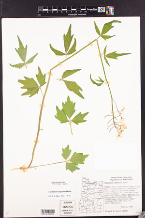
 | Brassicaceae 49. Cardamine angulata Hook.United States, Oregon, Yamhill: Along North Fork Trask Road .2 miles north of the Neverstill site, in the coast range. Elev. 498 45.42642°, -123.37104°. Datum: NAD83. Georeferenced by [automated process-OregonFlora/OSU Herb]. Coordinate Source: OrlookId: 97326, StateProvince: Oregon, County: Yamhill, LocName: 02S 06W 01. OregonFlora 1994-2020 methodology. On a very wet road bank. Alnus, Rubus spectabilis, Equisetum, Lysichitum, Acer, Pseudotsuga, Gaultheria, Polystichum https://oregonflora.org Richard R. Halse 3045Jun 6, 1985OSC-V-021770; Accession Number: OSC168066 |  OSC-V-021770_lg.jpg |
 | Brassicaceae 50. Cardamine angulata Hook.U.S.A., Oregon, Tillamook County: Between Pacific City and Dolph. 45.156829°, -123.86676°. Datum: WGS 84. Coordinate uncertainty: 8347 meters. Georeferenced by Deanna Michinski. Coordinate Source: Digital Map. Roadside, below rock wall with small waterfall adjacent. Flower color: white. Associated species: Saxifraga mertensiana, Corydalis scouleri. HPSU: 4987 Lee Kirkpatrick LK11984 |  HPSU003248.jpg |


